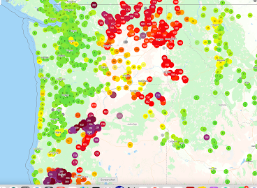
With the onset of moderate onshore flow, the smoke has been pushed out of western Oregon and Washington, with relief now spreading over eastern Washington (greens indicate good air quality, and yellow is acceptable).
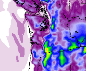
Moisture from ex-Hurricane Hillary has wet down the interior of the Northwest, with precipitation over the past 36 hr really soaking northeast Oregon and Idaho. Plenty over the eastern side of Washington State. Excellent news on many fronts, including the suppression of wildfires.
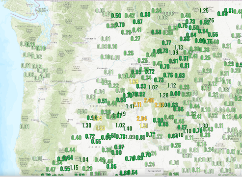
36-h rainfall ending 1 PM Tuesday
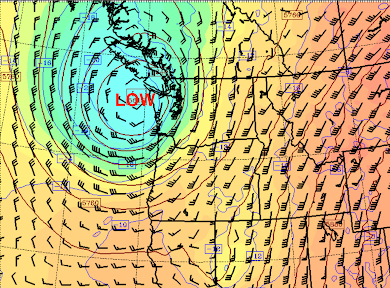
Currently, there is a potent low-pressure area along the Washington Coast (see upper-level map around noon today–Tuesday), which is keeping us cool and bringing some scattered showers to the coast.
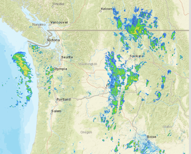
In fact, the radar image at 2 PM shows a moderate rain band approaching the Washington coast and the remnants of Hilary over eastern Washington (see below). Almost feels like autumn today.
But something has me worried.
Our region will warm up temporarily, Thursday through Sunday, probably into the mid-80s around Puget Sound.
But that is not what I am concerned about….but rather the potential for localized easterly winds over the western Cascades slopes during late Thursday and Friday. Easterly winds accompanied by low relative humidity could encourage wildfires.
It is important to note that mid-August to mid-September is the favored season for westside wildfires.
On Thursday, high pressure will build over Alberta and start to move southward into Montana (see map of sea level pressure, winds, and low-level temperatures at 11 PM Thursday).
That high pressure will force easterly (from the east) winds over the Cascades which will also result in warming and drying.

The geographical focus of the strong easterly winds will be the western side of the Columbia Gorge (see predicted wind gusts around 11 PM Thursday). Some easterly gusts to around 30 knots

And the Hot-Dry-Wind index, which considers dryness and wind, shows concerning values east of Portland (see below, yellow and red colors are the worst) late Thursday and early Friday)
Let me be honest…. I have seen a lot worse conditions than this (e.g., September 2020)…. but folks need to be careful not to start any fires on Thursday or Friday on the western side of the Cascades, particularly near the foothills of the Cascades near Portland.