Snow is coming back to the Washington lowlands.
Northwest Washington, from Bellingham to the San Juan Islands to the northern Olympic Peninsula, will experience a significant snowfall.
The Puget Sound lowlands will experience some flakes, and maybe even some limited freezing rain, but it won’t amount to much.
I waited to talk about this until I had confidence in the forecast.
Let me start by showing you the total snowfall (amount of snow falling from the sky) from the latest high-resolution UW forecast. Snow depth would be less.
The precipitation will reach us around dinner time today, but temperatures will be too warm for snow over most of the lowlands. Here are the predicted snow totals through 10 PM tonight. Light amounts over the Olympics and the southern Cascades.

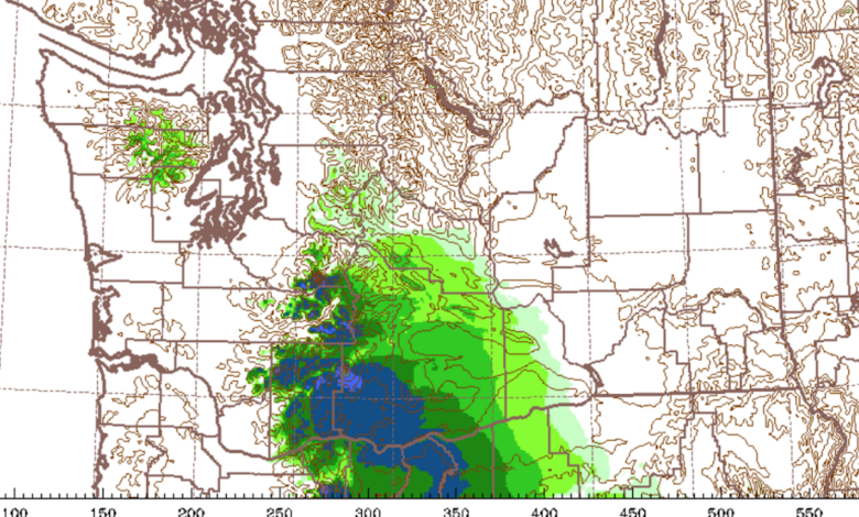
But gird yourself for a shock. Snow totals through 11 AM Wednesday are stunning. Significant snow over southern BC and northwest Washington. Bellingham and the San Juans will have several (up to a half foot) inches. Port Angeles is the same. Nice snowfall over the Cascades and ALL of eastern Washington.

And it doesn’t stop. The Cascades end up with 1-2 feet by 7 PM Wednesday. Keep that in mind if you are planning cross-Cascade travel. Whatcom County could get around 8 inches. Southern Vancouver Island, including Victoria, will be hit hard.

The MUCH lower-resolution European Center model is similar, so there is some confidence in this prediction (see below).

So what is going on?
This is an event in two acts.
In the first act, an occluded front associated with a low-pressure system offshore will move through our region. The satellite image (from around noon) shows the story.

The issue is that the atmosphere has warmed up considerably during the past day and is now too warm for significant snow over the lowlands. We know this because we get temperature information from aircraft coming in and out of SeaTac (see plot at 1 PM today below).
It is above freezing near the surface and aloft (above approximately 1600 ft), with a shallow below-freezing zone in between. There could be a few flakes getting to near sea level and perhaps a spot of freezing rain, but nothing of note.

But something special will happen tomorrow that will doom Northwest Washington!
The low center will move into western Washington (see surface map at 7 AM Wednesday) and this will pull cold air (blue in the figure) into NW Washington, particularly through the Fraser River Valley northeast of Bellingham.

The UW WRF model explicitly forecasts this cold flow as shown by the surface wind prediction at the same time (7AM Wednesday).
This northeasterly flow is quite cold enough to snow and thus Bellingham, the San Juans, Victoria, and the northwest Olympic Peninsula will get several inches.

There may be a few flakes over Puget Sound, but nothing significant.
Finally, in my previous blog, I noted that wind and solar were essentially zero for the Northwest in this situation. Well, the situation is still very bad (near zero generation) for wind and solar (green line). Hydro is doing most of the heavy lifting, with nuclear being a very valuable number two.
We need both hydro and nuclear and this situation will not change quickly.
This is reality.

red is total electrical demain, blue is hydro generation, green is wind and solar, purple is nuclear.