One of the interesting aspects of Northwest weather is the mid-October temperature transition to cooler temperatures, and this year will not be an exception.
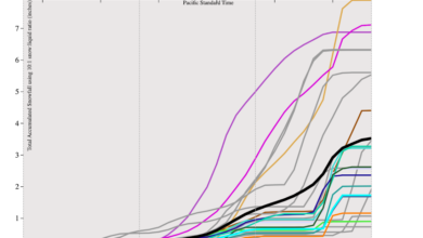
Below is the latest forecast of temperatures at Seattle from the National Weather Service GEFS ensemble of many forecasts, with the black line showing their average (generally a very good forecast).
Warm temperatures today, followed by a plummet towards highs only in the mid-50s for the next week.

Another skillful forecast system–the National Blend of Models– is also going for high temperatures only reaching around 55F for days at a time!

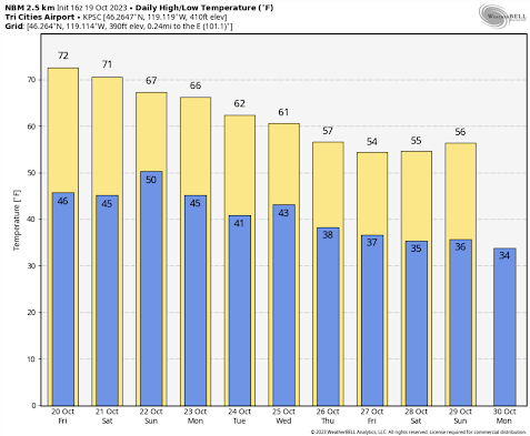
A similar story in the Tri-Cities:
This cool-down is right on schedule. I have always been fascinated by the rapid fall transition in our region.
Let me show you the climatology for Seattle during the autumn (below). The red line shows the record daily high temperatures, and the blue shows the record lows. The average temperature range by the brown band. The vertical blue line is today.
Before today, high temperatures have reached highs of 80F or more, but not after this date. The sun is getting too weak and clouds are increasing too much.
.png)
This date also represents the transition to the potential of below-freezing temperatures, which never occurred earlier in the fall.
And another transition looms in one month–after mid-November serious cold-air outbreaks and snow can hit western Washington.