Heavy Rainfall is Now Certain for the Northwest. But Why Are Some Folks So Worried About Drought?
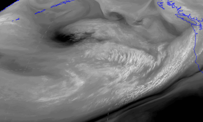
The latest water-vapor channel satellite image is quite ominous, with a series of very wet weather systems approaching our region.

The weakest of the bunch is starting to come onshore right now (on Saturday), but early next week will be seriously wet.
Let me show you.
The 72h total precipitation through 5 AM Tuesday, will make any duck happy (below_. 3-5 inches in the Olympics and even more over the mountains of southwest BC. Substantial precipitation in the Cascades and large amounts over SW Oregon and NW California.

But if you really want to be shocked by nature’s wet bounty, check out the one-week totals ending at 5 PM next Saturday. Wow. Western Washington, BC, and Oregon are hit hard, with some parts of the Olympics getting nearly 10 inches of rain.
The wildfire season will be over for the year folks…you can count on that.

All state-of-science weather forecasters use ensembles of many forecasts to gain an idea of the uncertainty of the forecasts. So below is the ensemble prediction of accumulating precipitation from the NOAA/NWS GEFS ensemble for Seattle. Each gray line is one forecast, the blue line is the high-resolution prediction, the black line is the average of all the forecasts, and time increases to the right.
All forecasts are going for heavy precipitation, with an average of around 3 inches in Seattle for the next week.
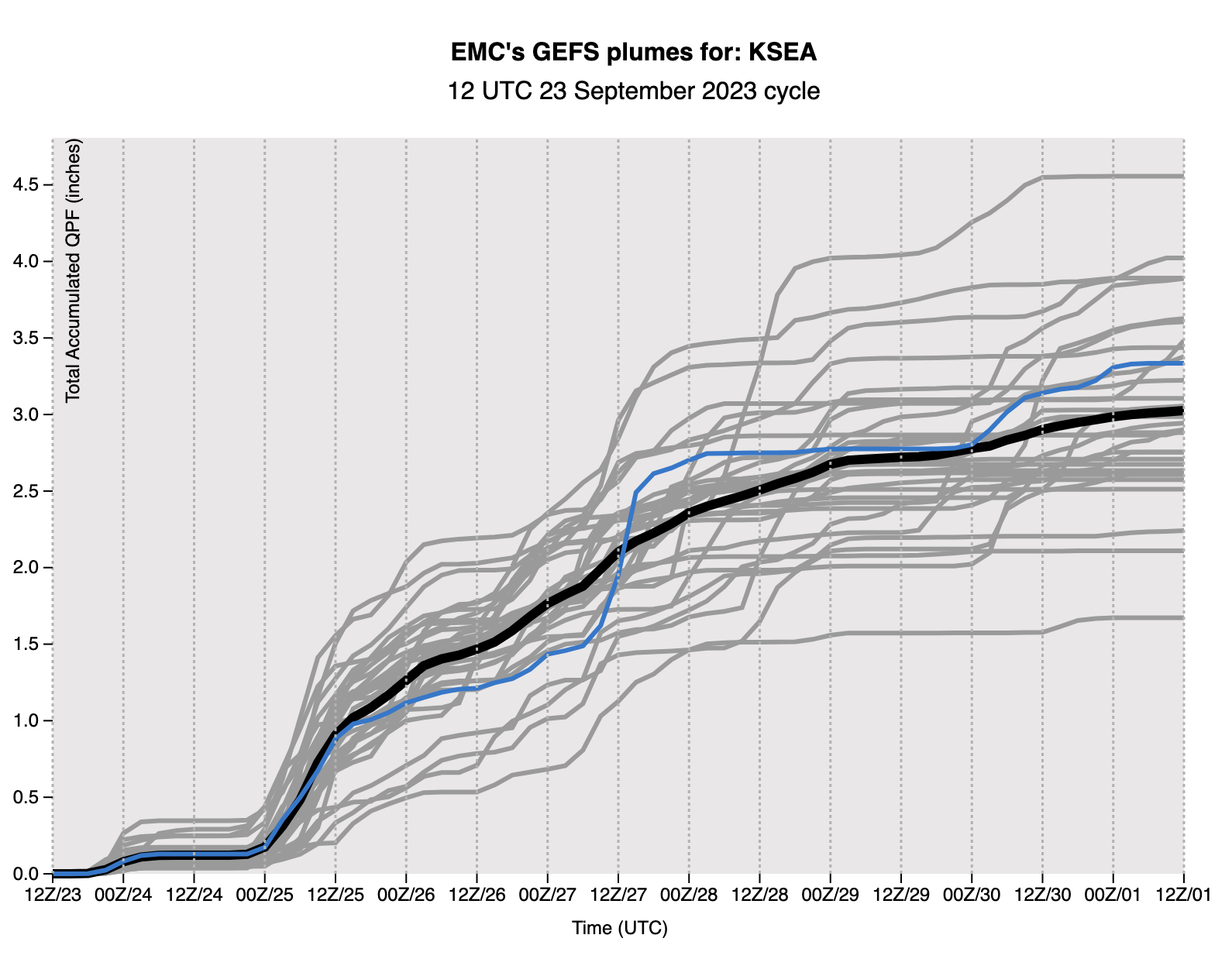
Rivers will rise rapidly, reservoirs will begin to refill, and you can forget about watering your lawn, outside plants, or anything else. September rainfall in 2023 will come in around double the normal amount (which is about 1.6 inches). In fact, this rainfall will ensure that our July-August-September totals are near normal (3.1 inches).
Disturbingly, considering this forecast of heavy rain, some unfathomable warnings and actions are taking place in the public sphere.
Of course, the Seattle Times suggested that were are in a serious “drought”, with a front page banner article in Friday’s paper (see below).
The Times describes an early melt of winter snowpack, hyped reservoirs that are less than 30% of capacity, talking about a “dwindling” water supply, and OF COURSE, blamed ‘”climate change, caused by burning fossil fuels, is making these types of hot and dry summers more frequent and making droughts more severe.”

Most of the ST claims are either false or highly exaggerated/deceptive. Let me prove this to you.
Let’s start with the snowpack plot from the Seattle Public Utilities website (below). The 2023 snowpack above Seattle’s Cedar/Tolt reservoir is shown in red, 2020’s amount in green and blue shows the normal situation. Our snowpack this year peaked above normal and later than normal, with the melt DELAYED from normal years. The Seattle Times needs a fact-checker!

What about the reservoir storage, which the ST notes is only at 30% of capacity?
Deceptively, the Seattle Times did not provide the truly relevant number, the current percentage of normal.
Let’s look at the reservoir level plot from the City of Seattle (below), showing this year, 2022, and the average.
You will note that reservoir levels are typically lower this time of year….perfectly normal and expected after the typical dry summer around here. After a warm, dry summer we are a bit below normal.
By how much? The average is about 30 million gallons of active storage and this year we are about 26 million gallons. So right now Seattle reservoirs are around 87% (26/30) of normal. Doesn’t sound as scary does it. Both the Seattle Times and Seattle Public Utilities should have said this. But they didn’t.

And what about the bogeyperson of global warming as the cause of our dry summer?
Completely unsupported. We were dry because of the persistent large-scale weather pattern that made California WET, and such patterns have no connection to global warming.
But I can prove this to you in another way. If global warming was a contributor to drier summers around here you would expect to see a long-term trend toward drier summers, since the earth is already warming from our emissions of greenhouse gases, such as CO2.
Here is a plot of summer rainfall (June-August) for the period of record (1904-2023), with a trend line put on for reference. Yes, the last summer or so has been a bit dry, but the trendline is UP (wetter). And many years were drier than this year. Really little indication of global warming, which should be most evident from roughly 1980 and later.
.png)
I know some of you are upset when I note errors and exaggeration in the Seattle Times and other media (and yes some politicians). But a democracy can not function properly if citizens are misinformed and the Seattle Times and others are doing so in a very deliberate, unfortunate way.
______________________________________________
You can attend in person or online.
And I would certainly welcome any UW undergraduate or graduate students.