Severe weather was moving east Wednesday, bringing flash floods and tornadoes to the New Orleans area and other areas of the central Gulf Coast, the National Weather Service said.
Forecasters said several flash flood warnings were issued earlier in the day, including one for New Orleans, where 1.5 to 2 inches of rain had fallen and 1 to 2 inches of rain was possible. 3 inches.
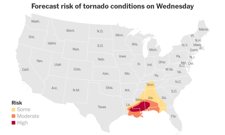
There is also a significant risk of tornadoes in the area and some could be very strong. The first tornado warnings have been issued for some rural areas and more warnings are expected in the morning. Forecasters warned that more than seven million people across Louisiana, Mississippi and Alabama could be exposed to severe weather throughout the day.
The weather in the area began to deteriorate before dawn. The Weather Service issued more than a dozen tornado watches and warnings covering towns from Texas to Mississippi. One of the more important bulletins was a tornado warning issued for the southeastern portion of Louisiana north toward Columbus, Miss., through early afternoon.
(A tornado warning is an emergency warning issued after a forecaster spots a possible tornado on radar or a trained observer sees a tornado. Watch means weather conditions are favorable for the formation of a tornado in an area.)
Flooding began hitting areas of east Texas early Wednesday morning. Schools were closed and roads closed Wednesday through the city of Kirbyville in Jasper County, Tx., in the eastern part of the state. The the sheriff’s office said Its deputies, local fire departments and emergency agencies were deployed to rescue efforts in the area surrounding the city of more than 2,000 people.
“We have major flooding throughout the mid-county and another storm is coming,” the sheriff’s office said, advising residents not to travel.
The Weather Service also issued a series of flash flood warnings, including one for areas around Jackson, Miss., which has nearly 400,000 residents.
Forecasters predict the cluster of storms approaching the region could dump up to 4 inches of rain in a short period of time from northeast Louisiana to southwest Georgia and the Florida panhandle. The storms are also expected to produce hail and high winds throughout the evening.
“Residents and visitors should have multiple ways to receive warnings and never drive through flooded roads,” the Weather Service said.
While most of the severe weather is expected to start in the morning and last into the afternoon, parts of Mississippi were reeling from the overnight storm.
At least one tornado was reported in Raymond, Miss., just west of Jackson, the state capital, according to a local news outlet. Many trees and power lines were downed in neighboring counties.
As of about 9 a.m. local time, more than 150,000 additional households in Louisiana were without power, according to PowerOutage.Us, which compiles data from utilities across the United States. More than 30,000 customers lost power in Mississippi and about 60,000 customers in Texas.
The National Weather Service office in New Orleans said on social media that the storms moving across the city on Wednesday would be gradual and some of the main impacts would be heavy rain and flash flooding.
In anticipation of the weather, officials closed City Hall and other city buildings on Wednesday. However, schools remain open.
Farther north, the Weather Service office in Jackson, Miss., warned residents that damaging winds of up to 70 mph were possible Wednesday, along with an increased risk of tornadoes. vortex, some places strong and hail.