La Nina’s days are numbered

La Nina, the periodic occurrence of unusually cool surface waters in the central and eastern tropical Pacific Ocean, has a significant but variable impact on Northwest weather.
In general, La Nina brings wetter-than-normal and cooler-than-normal conditions to the Northwest, often accompanied by a healthy local snow cover. Central and Southern CA are often dry.
But this year La Nina appears to be following a different scenario, with California being battered by wet storms. And La Nina is about to weaken rapidly, with changes already occurring below the surface of the Pacific Ocean.
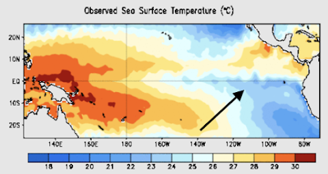
This is the most recent map of Pacific sea surface temperatures. You can see cool water near the equator in the central/eastern Pacific,
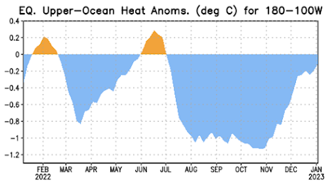
But below the surface, temperatures have begun to warm rapidly, as illustrated by the following graph, which shows the difference from the normal (thermal anomaly) of subsurface sea surface temperatures. face.
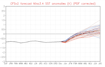
NOAA and others run computer-based predictive models that predict future tropical sea surface temperatures. This is the prediction of temperature anomalies (difference from normal) for the Nino3.4 region in the central tropical Pacific for a set of multiple models. Almost all will warm up when La Nina ends this spring,
NOAA’s climate model, CFS, is doing the same thing.
As a result of all these projections, the NOAA/NWS Climate Prediction Center predicts that the probability of a La Nina event drops to about 50% in February and much less in the following months.


