The upcoming winter may be an interesting one for the West Coast.
A very strong El Nino is rapidly developing. Strong enough that it could significantly alter the atmospheric circulation during the upcoming cool season, particularly after January 1.
As I have mentioned many times in this blog, El Nino is associated with warmer-than-normal sea surface temperature conditions over the central and eastern tropical Pacific.
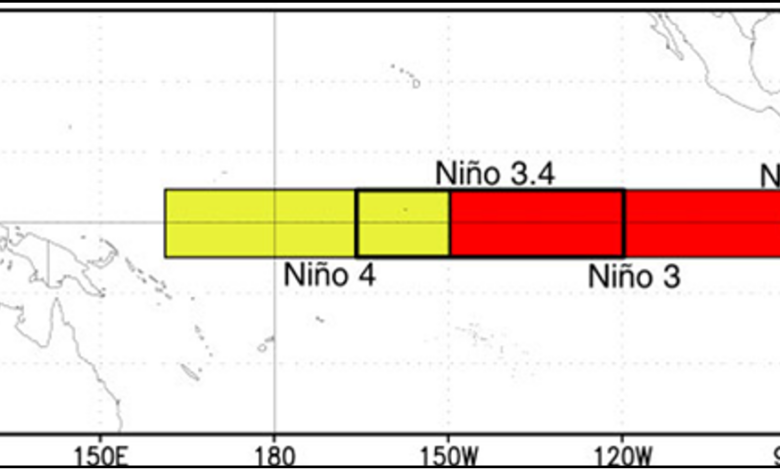
The most frequent tool for monitoring the potential for El Nino (and its opposite La Nina) is the sea surface temperature averaged over an area in the tropical Pacific, known as the Nino 3.4 area (see map below)

Major changes have occurred this year as we transitioned from La Nina conditions (colder than normal temperatures in the Nino 3.4 area) to a moderate El Nino (see plot below). In the figure, the Y-axis shows the temperature difference from normal in that area.
We are now solidly a moderate El Nino and the tropical ocean is still warming.

A map of the sea surface temperature differences from normal (the anomaly) is shown below. Mama Mia! That is a warm equatorial ocean.

In the U.S. the NOAA/NWS Climate Prediction Center (CPC) is responsible for predicting El Nino and La Nina situations. This is such a strong event and they are so sure that CPC is basically going a 100% for El Nino.

Why are they so sure? Because both simulation models and statistical approaches are going for an increasing El Nino, as shown below. We are talking about strong El Nino territory!

So what does a strong El Nino mean for our weather this winter?
A warm tropical Pacific has an impact on the atmosphere that extends into the midlatitudes, particularly after the New Year. In general, historical statistics suggest that the Northwest is a bit drier and warmer than normal and California gets more precipitation than normal.
Let’s also check the latest seasonal simulation forecasts ( from NMME).
The forecast for the precipitation anomaly from normal for January-March is for a dry Northwest and a west California. Classic.

And temperatures are predicted to be warmer than normal on the West Coast.

Let me make clear that the correlation between El Nino and West Coast weather is useful but not perfect.
Think of it weighting the atmospheric dice. But I would think carefully about buying that seasonal ski pass for a lower-elevation venue.