If society and an informed electorate are going to make good decisions about environmental matters, they require accurate information.
Unfortunately, there has been a lot of poor information about climate change, extreme weather, and drought being distributed by certain government agencies and some media.
One example is the nearly constant talk about drought here in the Northwest and the western U.S. in general, often with a suggestion of a climate change origin.
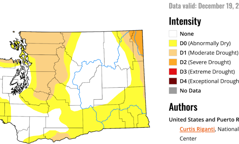
The most problematic source of the drought claims is the U.S. Drought Monitor graphic produced by a collection of governmental agencies. This is a subjective graphic, with no rigorous methodology based on objective information. And it exaggerates drought.
Consider the latest drought monitor graphic for Washington State (see below). Much of the central and north Cascades are in “Moderate Drought.” Whatcom County and Bellingham, plus Port Angeles to Sequim, are in moderate drought as well. The NE corner of Washington is in “Severe Drought.” And large additional areas are claimed to be “Abnormally Dry”

Before we go further, how is a drought defined anyway?
Precipitation has substantial variability over time, with as many years above normal as below normal. How dry does it have to be to considered drought conditions?
The National Weather Service definition requires not only a deficiency of moisture but “adverse impacts” over a “sizeable area.”

The main professional organization of meteorologists, the American Meteorological Society, requires dryness, length of time, AND a “serious hydrological imbalance”

In short, drought requires serious societal impacts. So have we been unusually dry lately? Have there been impacts? Let’s not be vague here…. we need to look at hard numbers and real impacts.
Let’s start by looking at the cumulative precipitation starting October 1–the beginning of the water year.
For Seattle, precipitation has been above normal (green is actual, brown is normal)
.png)
For Bellingham, in the middle of the “drought” area, precipitation is very close to normal.

What about the impacts of the “drought”?
Let’s begin by looking at the water situation in Seattle, whose watersheds drain from the middle of the moderate drought area!
The plot from the official Seattle Public Utilities website suggests close to normal water storage (the red line is this year and the blue line is the long-term average)

In fact, the Seattle SPS narrative suggests the reservoirs are a bit above normal:

What about regional rivers? Surely most of them draining off the mountains would be substantially lower than normal if a moderate drought was going on.
Here is the latest river-level information from the USGS.
Most rivers are near normal (green), some are above normal (cyan and blue), and some of below normal (orange and brown). Pretty close to normal overall. Soil moisture (not shown) is near normal.


So there is really no evidence of regional drought based on precipitation or impacts.
But something IS below normal: the regional snowpack. This is illustrated by the latest USDA Snotel plot (below), which shows the percentage of normal snow water equivalent in the snowpack. Most of the mountainous areas are 55-65% of normal, but some are worse, like the Olympics.

So how could snowpack be below normal while precipitation is near normal?
A potential answer: it has been warmer than normal….with the very strong El Nino being the probable cause. Below are the recent temperature deviations from normal. Above normal over much of the state during the past 60 days.

So what do the latest forecasts suggest for the next ten days? Below is the predicted cumulative precipitation for that period from the European Center model.
California gets hit hard (classic El Nino). Lots of precipitation over southwestern BC and decent rain along the Washington Coast. These amounts are below normal for the Washington Cascades.

The predicted ten-day temperature anomaly from normal is classic El Nino, with above normal temperatures over the Northwest and MUCH warmer than normal temperatures over the northern plains, with southern California and the desert SW below normal.

I worry about the snowpack this spring. We are dealing with a very strong El Nino and the “meteorological dice” are weighted towards a low April 1 snowpack.