This afternoon a powerful Arctic Front pushed southward into Washington State, on both sides of the Cascades.
As a reminder, an Arctic Front is the boundary of cold, dry air from northern Canada and the previous moist, warm air over the region. Winds behind the Arctic Front are often strong and gusty, particularly when it exits low-level gaps such as the Fraser River Valley.
And some light snow often accompanies this front as well.
The Arctic Front today was one of the strongest in years….. let me show you the details.
This Arctic Front hit like a freight train. Here is a video from Greg Johnson at Skunk Bay Weather showing what conditions were like over North Kitsap County after passage. Strong enough for white caps!
Conditions at Bellingham, downstream from the Fraser River gap, were stunning. Temperatures today dropped from near 40F this morning to 14F a 9 PM. At the same time, winds gusted to about 55 mph! (see below)


As a result, the wind chill at Bellingham is now well below zero (see below). And it will go lower.

The winds were so strong around Bellingham that a substantial number of power outages occurred:

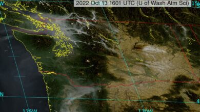
I plotted the location of the Arctic Front at 5 PM today (red line, see below). At that time is was located just south of Seattle and further south in Eastern Washington. Note that single digit temperatures have already entered the northern part of the state.

As the northeasterly (from the NE) Arctic Air hit the Olympics it was forced to rise, producing several inches of snow. The weather radar around 5:30 PM shows the upslope precipitation very clearly.

Here is a picture from SR 101 west of Port Townsend…..looks quite wintry.

What about snow?
It is pretty much over north of Seattle, with some snow showers remaining to the south. The latest UW snow total forecast from 4 PM today through 4 Saturday (below) suggests most of the snow will be over Oregon and the south Cascades.

The latest NOAA/NWS National Blend of Models forecast suggests a few more cold days in Seattle-Tacoma Airport followed by a warm-up (see below). The predicted low for Saturday morning is extreme (11F), with temperatures remaining below freezing most of the weekend. 11F would be the lowest temperature in many years at the airport.

Eastern Washington will stay colder longer, with the Tri Cities (shown below) dropping into the single digits through Tuesday.

Sweaters and thermal underwear might be good choices for the next few days. This going to be a hard freeze, which may damage some plants.