I have gotten several emails from readers asking about the snow situation.
What are the chances for a white Christmas in the lowlands? What about more snow for the mountains and ski areas?
I will do my best to answer these questions in this blog.
What is the snow situation right now?
The short answer is that current snow coverage and depth are below normal, with barely enough to run the regional ski facilities in Washington.
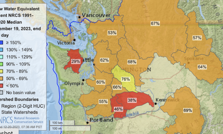
Let’s begin with the latest USDA Snotel maps (below). Most of the mountainous areas are 55-65% of normal, with the Olympics (29%) being a low outlier (due to a warm, atmospheric river a week ago).

To get a total view of the regional snowpack, consider the latest snow depth graphic from the National Snow and Ice Center. Nothing over the lowlands (no surprise) and only modest amounts in the mountains. Oregon is not in good shape regarding snow.

A year ago, when La Nina was in place, there was a lot more snow, which extended down to lower elevations.

Looking to Christmas Day and beyond
Over the next 96 hr (through 4 AM Sunday), there will be only modest snow in the mountains, as suggested by the high-resolution UW modeling system (see below). Enough to make up for melt and sublimation, but now enough to meaningfully improve the situation. The European Center forecast forecast is similar.
.gif)
Then it dries out for a while. So no white Christmas for western Washington and Oregon.
But the mountains have a chance for more significant snowfall later next week. An upper-level trough will approach our coast on Wednesday, as shown by the 500-hPa map (about 18,000 ft) on Wednesday (below).

This feature will bring significant snowfall to the mountains. To illustrate, the map below shows the accumulated snowfall through 10 AM Thursday. British Columbia gets many feet from this event (great for Whistler) and Mt. Baker will get a significant snow dump. Not much for Oregon.

Finally, any good forecast should provide the uncertainty of the prediction. Here is the snow predicted at Stampede Pass from the NOAA/NWS GEFS ensemble system of many forecasts. All the models agree on some light snow before Christmas, but there is a lot of uncertainty regarding the major snow event next week. Be warned! Will have to keep an eye on this forecast.