After a record-break string of cold weather, with ice and snow extending to many low-elevation areas in the Northwest, some very welcome warmth is coming.
In western Washington. you can say goodbye to the teens and twenties and welcome temperatures climbing into the 50s. Eastern Washington will thaw out.
And ample precipitation will return to the West Coast, helping to push off concerns about drought.
Winter is running out of time with ice/snow conditions over the lowlands becoming far less possible in roughly a month.
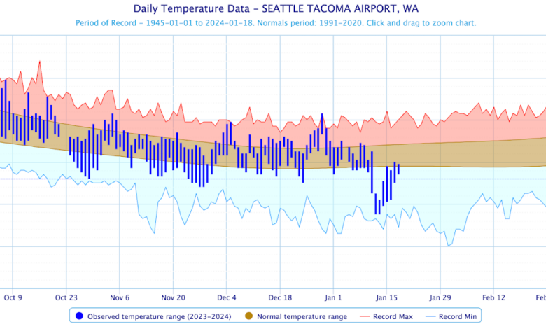
Strangely enough, if one averages over time, this winter has not been unusual, a fact that probably will not gain the interest of the media. Looking at the temperatures at SeaTac (blue lines) versus the normal range (brown band), we were cooler than normal in November, warmer than normal in December, and uber-bold in January.

Preciptiation? Amazingly the total since October 1 (known as the water year) has been nearly exactly normal. No drought.

Eastern Washington has a similar story, as shown by the precipitation in the Tri-Cities.

And now the part that will warm your heart and other body parts.
The predicted temperatures in Seattle for the next 12 days is for warmer than normal conditions, with many days getting into fifties. You won’t even see thirties.

The Tri-Cities into the mid-40s by the end of the period.

So what has happened?
The key is that the influx of modified Arctic air from the interior of the continent ends, with the loss of cold air over the Columbia Basin and the interior of British Columbia.
You can see this for yourself. The maps below show sea-level pressure, low level temperatures (at around 800 m, color shading, with purple and blue the coldest), and near surface winds.

But by 1 PM on Monday, the interior Northwest was warmed dramatically, with all the blue colors gone.

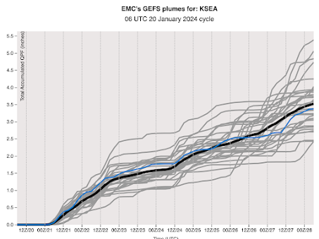
Now only will we warm, but normal precipitation will return. The latest ensemble prediction of many forecast simulation from the NWS GEFS system shows Seattle receiving about 3.5 inches during the next ten days.
The UW model’s cumulative precipitation forecast for the next ten days will bring a smile to local ducks and slugs, with substantial precipitation (reaching totals of 10 inches in the mountains), from central California to British Columbia.
Many of the fears for water problems from an El Nino winter will not be realized, which is good news.