3:30 PM Thursday. An intense Arctic front is moving southward through Puget Sound Country and Eastern Washington now. Some ice pellets and snow with it. Will blog about it later…..
_______________________________________
The threat of Puget Sound snow has now faded as the U.S. weather prediction model, the GFS, has come into agreement with the European Center model, the IFS.
A more serious threat is now front and center, extremely cold air moving south out of the Canadian Arctic.
Air that presents a mortal threat to the unhoused.
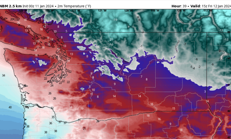
Let’s start with the temperatures predicted by the National Weather Service National Blend of Models (NBM), which statistically combines forecasts from many different sources. A system that predicted the unusual heatwave in 2021 almost perfectly, days in advance.
The surface air temperatures predicted for Friday morning at 7 AM show the coldest air over the interior of British Columbia and starting to move south into northeast Washington.
Temperatures at this time are predicted to drop into the lower 20s F around Puget Sound and single digits in the Columbia Basin.

Saturday morning will be considerably colder, with temperatures dropping into the mid-teens over central Puget Sound to Portland. Eastern Washington will range from the single digits to well below zero.
Sunday morning will be similar.
The coldest air will stream into Puget Sound through the Fraser River gap northeast of Bellingham. You can see this clearly by surface winds predicted for Thursday night at 7 PM. Cold, northeasterly winds will push over the San Juans and then plow into the Olympics, with some of the air rising on the mountains, producing localized snow.

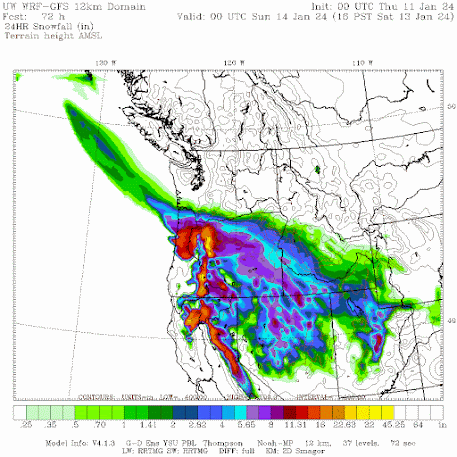
To show this, here are the snow totals through Friday morning at 4 AM. Some snow in the mountains and a subtle band near Everett.

Later on Friday and Saturday, a weather system will move eastward to our south, with the associated low center moving into Oregon (see sea level pressure forecast for 1 PM Saturday).

The poor folks near Portland and northwest Oregon will be hit very hard, with substantial snow (see 24h snow totals through 4 PM Saturday). Extremely strong easterly winds will exit the Columbia Gorge from Troutdale to Portland, with gusts reaching 50-70 mph.
Your have to feel sorry for those poor folks in Portland–they had another major snow event a year ago.
Finally, to put this event in perspective, below are the lowest annual temperatures in Seattle for its entire record. If Seattle gets as cold as 16F, we would experience the lowest temperature since 2010.

Stay warm.