Over the last century, governments around the world have drawn boundaries to shield thousands of the world’s most valuable ecosystems from destruction, from the forests of Borneo and the Amazon to the savannas of Africa.
These protected areas have offered lifelines to species threatened with extinction, supported the ways of life for many traditional communities and safeguarded the water supplies of cities.
But reserves are facing increasing pressure, their boundaries largely disregarded as people cut down trees and push deeper into the ecosystems set aside for protection.
Now, high in orbit, a new way of seeing forests is making it clear that, even when under assault, protected areas can still be a crucial buffer against climate change. Scientists are using laser technology to gauge the biomass of forests all around the world, which lets them calculate how much planet-warming carbon the trees are keeping out of Earth’s atmosphere.
Quantifying the ability of protected ecosystems to store planet-warming carbon has long been a challenge for researchers. That’s largely because older, flat satellite imagery can’t distinguish how tall or wide trees were.
“We can use these new satellite data streams to monitor forest benefits in three dimensions and do the carbon piece of this in a way we never were able to before,” said Laura Duncanson, a remote sensing scientist at the University of Maryland and one of the authors of a study based on the new data.
In the past two decades, according to the research, protected areas around the world have helped stop deforestation and kept as much as a year’s worth of fossil fuel emissions from being released into the atmosphere.
The study, which was published this year, showed that policies designed to protect nature can also be important for mitigating global warming, Dr. Duncanson said. She called the findings “a beautiful side benefit” of global forest conservation.
‘People are eager to take whatever is left’
The Tapajós Environmental Protection Area, a forest in Pará State, Brazil, that is larger than New Jersey, was created in 2006. It is meant to act as a “green wall” to contain a surge of destruction in the Amazon rainforest that came with a newly paved highway known as the BR-163, said Mauro Pires, the president of the Chico Mendes Institute, the government agency that oversees reserves in Brazil.
Today, despite its protected status, the Tapajós is among the most heavily degraded areas in the Amazon. Its rivers have been contaminated with chemicals from illegal gold mines, and it has lost at least 3 percent of tree cover since it was created almost two decades ago.
Keeping tabs on the region is a huge challenge, said Ronilson Vasconcelos, who runs a 17-member team that is responsible for monitoring a dozen protected areas, including the Tapajós.
“People are eager to take whatever is left, like gold and timber,” he said. “It’s hard to get people to let go of something that’s making them so much money.”
But according to the recent study, the Tapajós is still one of the world’s forests that is most successful at avoiding carbon emissions. Comparing the reserve to areas that were similar two decades ago but were never officially protected, researchers concluded that if the Tapajós had been wiped out, additional carbon equivalent to the amount produced by 900,000 Americans would have ended up in the atmosphere each year.
“It’s very clear that it worked,” Mr. Pires said, but it’s not “a work of magic.”
Although many nations have agreed to protect more of the world’s ecosystems, political pressure to get rid of reserves is growing, and keeping them safe is becoming harder.
Protected areas, long thought to be shielded by their remoteness, are increasingly under threat as countries expand their economies.
“Nearly all protected areas are becoming much more accessible and much more vulnerable,” said Lisa Naughton, a researcher who studies protected areas at the University of Wisconsin-Madison. “Not just to local subsistence hunting and illicit timber extraction, but to things like artisanal mining and road penetration.”
A ‘missing piece to our understanding’
For decades, scientists have sought more effective ways to calculate the amount of carbon stored in forests, grasslands and mangroves.
Then, in 2018, NASA started a mission called the Global Ecosystem Dynamics Investigation (or GEDI, pronounced like the order of knights in “Star Wars”) that deployed a sensor in space with the power to make precise 3-D measurements of the vegetation below.
“That was, really, a very important missing piece to our understanding of the global carbon cycle,” said Ralph Dubayah, the mission’s principal investigator.
For the study published this year, researchers working with GEDI used the data to compare hundreds of thousands of protected areas around the world — including Californian redwoods, Indonesian mangroves and European woodlands — to an aggregate of areas that were similar in the year 2000 but had been left unprotected.
Then they calculated how much carbon held by each of these ecosystems would have been lost to the atmosphere without protections.
Those calculations still require scientists to make assumptions, said Maurizio Santoro, a researcher at Gamma Remote Sensing, a Swiss company, who was not involved in the recent study. Calculating how much carbon a given ecosystem holds requires knowledge of what species exist there, and, in many cases, that picture is incomplete.
Still, he said, GEDI allows scientists to do something that wasn’t possible before.
Reserves were most meaningful, the study found, where they blocked the surge of destruction happening around them, even if imperfectly. (Some protected areas locked away huge amounts of carbon but didn’t make as much difference overall because the surrounding areas were not under threat.)
“This is not to say that protected areas are these pristine, untouched places where forest carbon never gets lost,” Dr. Duncanson said. But, she added, “in places where you have a lot of deforestation happening, unless you have protection, there’s a high, high chance that those forests are going to be lost.”
Protected areas can slow degradation by affecting the flow of investment even when boundaries are not strongly enforced.
Many corporations, for example, won’t build a timber project in a legally questionable area. And public infrastructure, like roads, is often diverted to unprotected areas. Aspirational farmers may choose not to deforest an area because they believe they will never get a clear title to the land.
“If you talk to the people that do hunting, charcoal-making, timber, they know in a way that there is somewhere, even if it’s not materialized clearly on the ground, a line that should not be crossed,” said Paolo Cerutti, the head of the Center for International Forestry Research’s operations in the Democratic Republic of Congo.
Experts say that actively protecting reserves is critical to keeping them intact. Efficient law enforcement teams are essential, Mr. Pires, the Brazilian official, said. Without them, reserves gradually lose their perceived value and governments come under mounting pressured to lift protections altogether. In addition, Indigenous people and other traditional communities, who in the past have been forced out of some protected areas, tend to be highly effective at keeping trees standing.
The NASA program was paused in March, but it is expected to come back online early next year and produce more data until 2026, when the mission will be reassessed.
Researchers from the program hope that a longer-term record of forest carbon data will help governments prove the value of safeguarding native ecosystems and attract more funding for protection. The fight to curb climate change may depend on their success.
Countries with large forests have the ability to reduce their emissions at a lower cost through conservation, Mr. Pires said. But first, he said, they “need to implement these areas and give them the conditions to remain safe.”
Methodology
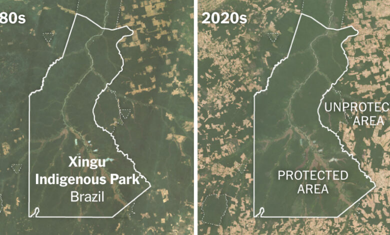
The before-and-after images of protected areas were created using historical imagery from Landsat, an Earth-observing satellite mission jointly managed by NASA and the U.S. Geological Survey, and were compiled using Google Earth Engine.
Each image reflects a multiyear average. Mosaics of the 1980s were created using imagery from Landsat 4 and 5 collected between 1984 and 1990. Mosaics for the present were created using Landsat 7, 8 and 9 imagery that was collected from 2020 to 2023. To reduce the influence of seasonal variations on vegetation, those date ranges were further narrowed. For example, the images used to create the Tanzania mosaic were limited to those collected between June and September of each year. Clouds, cloud shadows and water pixels were also filtered out.
Protected area boundaries were downloaded in November 2023 from UNEP-WCMC and IUCN 2023, Protected Planet: The World Database on Protected Areas.