It’s finally happening.
The nasty El Nino, with warmer-than-normal surface waters across the central and eastern tropical Pacific, is finally fading.
And the effects of El Nino, including on wet California and the warm Northwest, will fade.
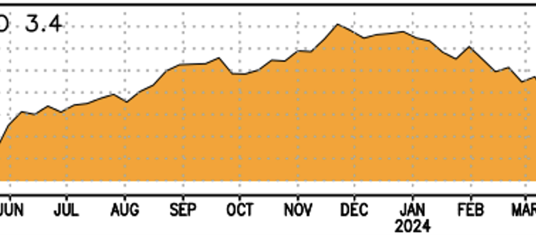
Consider the temperature in the Nino 3.4 region of the tropical Pacific shown below (differences from normal are illustrated). El Nino peaks at the end of November when sea surface temperatures increase by about 2.1 degrees Celsius. Currently temperatures are about 0.6C higher than normal and are falling rapidly.


The latest prediction of the NOAA/NWS climate prediction model (CFSV2) is that El Niño will disappear (0°C anomaly above normal) by the end of May (see below). And then we move into a strong La Nina (cold tropical Pacific) spell in the fall.

The model predicts an increase in colder-than-normal surface waters over the tropical Pacific over the next few months (see below). OH. Talk about oceanographic whiplash.

With El Nino weakening, widespread weather patterns are developing and the Northwest weather situation is forecast to be very different in the coming weeks compared to early winter.
During El Niño winters (and this winter), southern California is very wet, with the northwest being drier. In contrast, the latest cumulative forecast from the US GFS model through May 11 is shown below. Almost nothing will happen in southern California and wet conditions will prevail in the Northwest.
Something has changed.

And a strong La Nina heralds big changes next winter, greatly increasing the likelihood of more mountain snow and colder-than-normal temperatures.
____________________________