The visible satellite image this morning was stunning.
Low-elevation clouds covered nearly all of Washington, except for the highest elevations (see image)

Some folks were in fog while others looked at a low-stratus cloud deck.
And this cloudy murk was cold, with much of the state below freezing (see minimum temps this morning). Freezing fog was widespread.

Cold, cloudy, foggy and icy. Yuk.
What can you blame for this unpleasant situation?
Persistent high pressure. A strong ridge of high pressure aloft.
The upper-level map (500 hPa pressure, about 18,000 ft) on Sunday evening shows the situation (see below).

The difference from normal of 500 hPa heights (or pressure) for the last week was way above normal (see below, red indicates strong ridging…which is the same as high pressure aloft).
Translation: the high-pressure aloft was very strong and persistent.

In the summer, such a pattern would give us a heat wave.
But in winter we get a cold wave! But why?
High pressure is associated with sinking air aloft, which kills middle and upper-level clouds.
Without clouds, the Earth can effectively emit infrared radiation into space. There are no clouds to get in the way! Nights are very long and the sun is wimpy, so solar heating is weak.
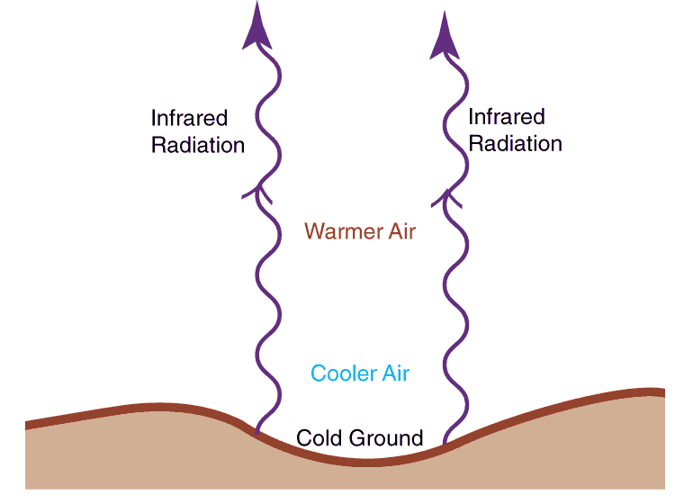
The ground cools more effectively than the atmosphere aloft and this helps create an inversion, with temperature WARMING with height. The inversion is also strengthened by the high-pressure aloft, whose sinking motion warms the air aloft (air warms as it sinks due to compression by the higher pressure at lower levels).
The inversion is a very stable feature and prevents the mixing of air at lower elevations. It protects the low-level cold air from mixing out.
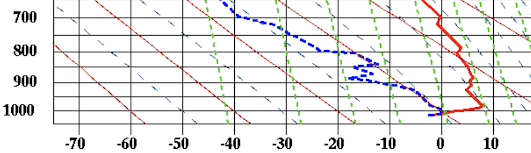
Want to see the inversion? Here is a plot of temperature (red) and dew point on the Washington coast at Quillayute on Tuesday morning. Temperature is increasing with height at low levels. An inversion!
Each day the air got colder near the surface. Cold air can hold less water vapor than warm air. Water vapor starts to condense out into low clouds and fog.
And it is even worse than that. The top of the clouds reflect solar radiation back to space, enhancing cooling. Clouds are good emitters of infrared radiation. More cooling. Low clouds are cooling machines!
So if you want to blame the cold, cloudy weather on something, blame the high pressure!
We escape this run-away cooling in the summer because of the far stronger solar radiation, which is able to heat the surface and destroy the low-level inversion.