The pattern was scary good tonight.
A double convergence zone is expected to form tonight, producing heavy rain, thunder, small hail and yes…snow.

There have been reports of snowfall around Everett (Paine Field), Marysville and at SeaTac Airport.
And snow was reported earlier in the higher hills around Bellevue (see below)
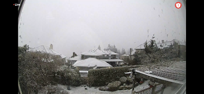
Snow at 1170 ft in Bellevue. Image courtesy of Dr Peter Benda
In the radar image above, the orange and red areas indicate heavy rainfall and small hail combined with strong convection, including thunderstorms. Some have reported thunder. And there were major blackouts south of Seattle that I suspect were caused by thunderstorm activity (see below).