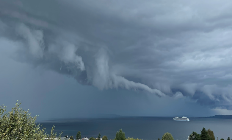
A lone cruise ship was heading into the terror…..would it survive?

Murphy was a brave soul and he took an extraordinary video, which is shown below.
Particularly terrifying were the torn-up, fractured clouds hanging out of the general cloud feature. Surely the work of some Lucifer-like creature.
This video is real–not the creation of AI or some Hollywood disaster flic. Just to prove this to you, here is a view from the Seattle PanoCam, located on the Seattle Space Needle at 12:10 PM

You can see the cruise ship heading into the murk. Reminds me of the movie “Final Countdown” in an aircraft carrier moves into such a feature and comes out at a different time.
Ten minutes later, the line is approaching Seattle and the ship is gone behind a curtain of rain….or is it something more ominous?

So What Was It?
A strong convective line, made up of thunderstorms and heavy showers, was moving through and the ominous feature you see is called a shelf cloud.
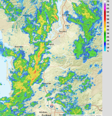
Let’s begin by showing you the radar image right before the images above (12:07 PM). Red is very heavy rain or hail. Orange and yellow are just heavy rain. You see the corrugation of the feature….another indication of a powerful line.
The shower line was made up of a series of strong cumulus convective elements, including thunderstorms.
Leading the strong storms was a cool outflow of powerful winds….called a gust front. The gust front pushed air up ahead of it, producing a shelf cloud (see schematic below)
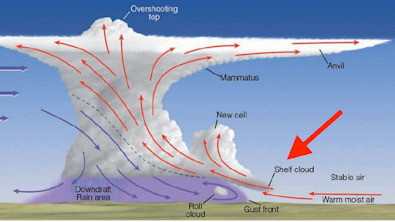
The flow at the leading edge of the gust front–with strong, cold sinking air behind and warm, moist upward-moving air in front of it– can be turbulent. leading to tendrils of upward motion that produce unusually fractured clouds. That is what they are called fractus clouds!
And when the line went through, the weather got very interesting. A profound drop in temperatures, an increase in winds, and, of course, heavy precipitation. Check out what happened as the line passed across the UW (see below).

And the weather fun is not over. An intense mini-low moved across the Oregon/Washington border, bringing strong winds to the northern Oregon coast (see forecast map for 2 AM today).

Enjoy the weather.