The ability to forecast the potential for wildfires, and particularly grass/rangeland wildfires, has advanced substantially during the past decade.
To illustrate the state-of-the-art of such prediction, consider the recently initiated (Saturday afternoon) Eagle Bluff wildfire that started near Oroville, WA, just south of the Canadian border. Roughly 16,000 acres of mainly grass and rangeland, with some isolated timber, have burned so far.
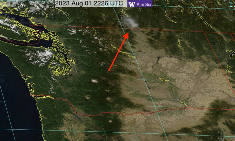
You can see the smoke from the fire in the latest visible satellite image (below). No other significant fire in Washington State.

The boundary of the fire is shown here (red colors), placed over a satellite image. The fire started south of the border and then pushed northward.

Here is the kind of landscape that burned: grass and range vegetation mainly.

As made clear by the USDA FuelCast analysis, the area had plenty of dead surface fuel (like dried-out cheatgrass) after a wet spring last year….see the FuelCast diagnostic below.


And such grass was dried out and seasoned, as would be expected by mid-summer.
To get a big fire all that was needed was ignition and wind. Well, we can’t predict ignition, but unfortunately, there are a lot of irresponsible folks around.
But we can predict the wind. Really well.
The USDA Forest Service has developed a diagnostic called Hot-Dry-Windy, which is wind speed multiplied by a measure of atmospheric drying called Vapor Pressure Deficit (VPD).
As part of my regional weather prediction modeling work, we predict Hot-Dry-Windy (HDW) out several days. Below is the 21h forecast of HDW valid just when the fire started (around 2 PM on Saturday). Green is a threatening value.
Eureka…just nailed it.

The high-resolution WRF model predicted strong southerly winds at the time of fire blow-up, as shown by the 21-hr wind forecast below (yellow colors indicate winds of 20 knots or more).

What actually happened? Here are the observed wind gusts at the nearby USDA RAWS observing station near Oroville. The wind surged on July 29th, reaching around 40 mph!

The Eagle Bluff fire is a repeat of the same story I have told before for other fires this year in our area.
- Grass and range vegetation, made worse by invasive cheatgrass over the region.
- A wet spring that encouraged bountiful growth.
- Normal drying (not connected with global warming).
- Strong winds.
- A careless ignition by some individual.
- And an excellent forecast of the winds.
Could we use our excellent weather prediction capability to warn folks more emphatically to be careful?
To get firefighters on scene BEFORE the fire starts?
Finally, one might note that wildfire is not unexpected east of the Cascades–it is a normal aspect of the ecology of the region. We just don’t need to help it along so much….


![Tropical Tidbits - [Sat / Aug 28] Hurricane Ida is strengthening rapidly as it approaches Louisiana](https://news7g.com/wp-content/uploads/2021/11/144701_key_messages_sm-390x220.png)