Yesterday’s high at SeaTac was 84F and today much of the central and south Sound reached the upper 70s to low 80sF.
But with a significant shift towards a more autumn-like pattern this week and a rapidly weakening sun, there is a good chance that SeaTac Airport and much of Puget Sound country will not see another eighty-degree day until next spring.
Take a look at the visible satellite image this afternoon (below). The Pacific Ocean does not have a summertime look! A weak, but broad, frontal system is offshore and some of its clouds are moving in tonight. A more potent cyclone and front is now over the Gulf of Alaska, and we will get a taste of its southern portions in a few days.
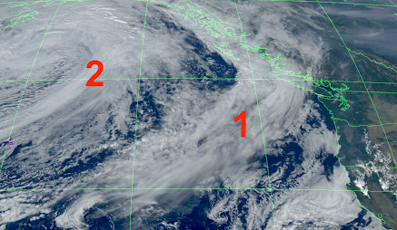
The most notable feature in this morning’s satellite image was a plume of smoke from a few small, lightning-caused fires near Hurricane Ridge in the Olympic Peninsula. Considering its location and its natural origin, the Park Service is letting it run its course.

Turning to the forecast, here are the predicted temperatures through 26 September in Seattle. Highs in the 60s and lower 70s.

As shown by the climatology data for SEATAC, with the red shading showing all-time daily records, once one gets into October, hitting 80F is increasingly unlikely, after mid-October it never has happened!
.png)
What about rain?
We are likely to get some.
The first band will be relatively weak, with the total through 5 PM Monday only bringing light showers to western WA, but more meaningful precipitation over southwest BC. Cooler temperatures and high humidity will knock back the Olympic Mountain fires.
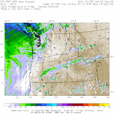
The second, more potent system will come in on Tuesday/Wednesday morning, with real rain over NW Washington and southwest BC.

Finally, I am getting a number of complaints from blog readers in southern CA about the wet summer. Did you know this was the wettest summer on record in Los Angeles… going all the way back to the 1940s? Wow.
.png) |
As a result of bountiful California rain and cooler-than-normal temperatures, wildfires are well below normal this year in CA (and were also below normal last year).
Want the proof? Here are the last statistics from CALFIRE, the official fire agency in California. The media likes to paint an “end of world” picture about wildfires, but the truth is different.