As noted in a previous blog post, late July and the first week of August are typically the driest times of the year. Time for outdoor weddings.
And for Seattle, today is historically the driest day of the year.
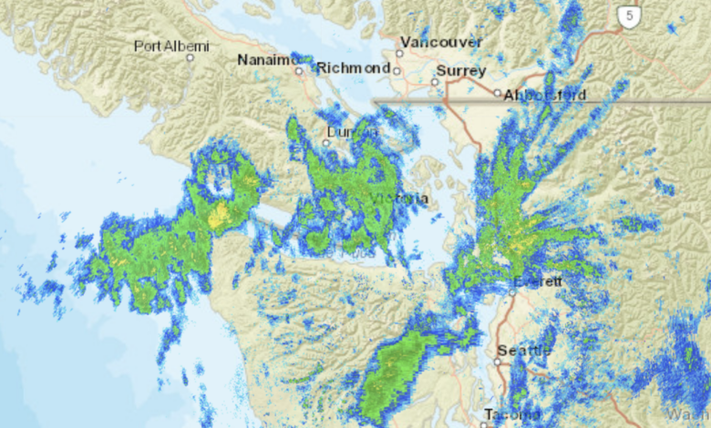
Going against the climatology, a relatively wet weather system has moved in today, and the moisture is not leaving, as NWS radar imagery shows around 8 p.m. Monday (see below). At this time, some healthy rain bands are moving in from the northwest.
The air feels “sticky” with a high dew point (around 60 degrees below), as the rain falls into relatively warm air.

Rainfall totals so far today have been impressive (see below). Bellingham has received 0.78 inches (a record for the day) and some foothills east of Bellingham have received over an inch. Southern BC has had a lot of rain and our coast has received about 3/4 inch. Central Puget Sound has received about 0.25 inches with a lot of variation.

More rain is forecast for tomorrow (see 24-hour forecast ending 5 p.m. Tuesday), and the combination of this rain and much cooler than normal temperatures will significantly reduce the risk of wildfires in many areas over the next week. As shown in the forecast map below, northwest Washington and the western slopes of the region’s terrain will receive most of the additional rain.

Things will dry out after tomorrow (Tuesday) and temperatures will return to normal and then slightly above normal (highs in the low 80s for most of western WA). Today was the coolest day in a long time for the area, with only a few stations reaching 90F in southeast Washington.
Rainfall and cooler conditions have significantly reduced the risk of wildfires (see official estimates below, green is good). Western Washington is in good shape for next week, with drier conditions returning later in the week east of the Cascades).

My next post will describe how this year has seen quite a few grass fires but relatively few forest fires.