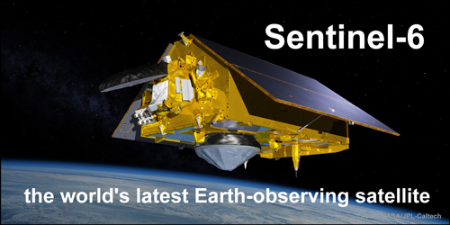
Guest Essay by Kip Hansen — 31 March 2022

SciTech Daily proudly announced on 27 March 2022:
“On March 22, the newest U.S.-European sea level satellite, named Sentinel-6 Michael Freilich, became the official reference satellite for global sea level measurements. This means that sea surface height data collected by other satellites will be compared to the information produced by Sentinel-6 Michael Freilich to ensure their accuracy. “ ….
“These missions, of which Sentinel-6 Michael Freilich is the latest, are the gold standard when it comes to sea level measurements, which are critical for understanding and monitoring climate change,” said Josh Willis, Sentinel-6 Michael Freilich project scientist at NASA’s Jet Propulsion Laboratory in Southern California.”
“Long-term records of sea level height are key to monitoring how much, and how fast, the oceans are rising in a warming climate. “We can’t lose track of how much sea level has gone up because if we do, it’s hard to predict what’s going to happen in the decades to come,” Willis added.”
“The unprecedented accuracy of the sea level measurements provided by this mission ensures not only the continuity of a 30-year data record, but allows improving our understanding of climate change and the impact of rising seas on coastal areas and communities,” said Julia Figa Saldana, ocean altimetry program manager at the European Organisation for the Exploitation of Meteorological Satellites (EUMETSAT).”
The measurement (sort of) of sea level by satellite telemetry began in late 1992 with the first TOPEX/Poseidon satellite, followed by Jason 1, 2 and 3. There were a few other short term satellites involved but NOAA gives us this graphic version:
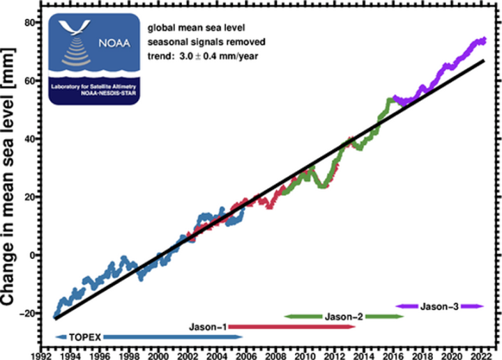
Charting the data from the .csv file for that same graphic in Excel gives us this:
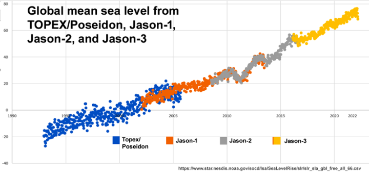
The two charts give quite a different visual impression.
In the top chart displayed by NOAA, the data “have been smoothed with a 4-month boxcar filter.” I have no idea why this is being done, but in January 2020, I discovered the fact in personal communication with Eric W. Leuliette, Branch Chief, NOAA’s Laboratory for Satellite Altimetry. He kindly added a note to this effect at the top of the NOAA web page which displays the graph.
In the Excel-produced chart from the data file, we see a lot of variability, particularly in the Topex data, with the variability narrowing in later missions. This graphic also is more linear. The last 15 months look like this:
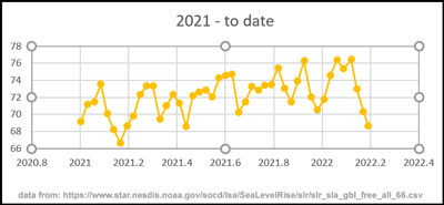
The last four data points show a drop in sea level of 8 mm, which may be the seasonal drop in the Northern Hemisphere winter.
The press release quoted at the beginning claims “unprecedented accuracy of the sea level measurements provided by this mission”. If this is meant to refer to the new satellite, Sentinel-6, then we can compare this to the accuracy of the previous Jason missions. For the Jason missions, the technical specification for original measurement error in the altimetry function of Jason’s 1, 2 and 3 of +/- 3.4 cm. [Ref: Jason-3 Products Handbook, Section 2.3.1, pg 10 ], with a hope that this new requirement could “enable reduction of sea-surface height errors to 2.5 cm RMS.” Now, understand that that is the specified requirement for accuracy of each and every single surface height measurement by the Jason missions. That range means that every measurement made must be guaranteed to be within a band 6.8 cm wide, 95% of the time. Let’s be clear, that 6.8 cm is 20 times the size of the signal (change) claimed to be found between many of the individual GMSL data points in the NOAA data file. If one looks again at the Excel-produced graph of the data file, we see that the individual data points for Topex themselves have a month-to-month range of 20 mm, which signifies that if we add the specified allowable uncertainty range, we have a total accuracy range of 88 mm (about 3.5 inches). In the latest missions, this figure is reduced (through lower month-to-month variability) to about 73 mm (2.9 inches). Summarizing, the expected combined standard uncertainty for Jason 1-3 was +/-3.4 mm giving a total range of uncertainty for the data set of about 73 mm – about 3 inches — in present time.
Note: This last assumes that the range must include the variability – which some may disagree with – but it follows from the logic that the sea surface height is not physically changing rapidly enough (in the ten days between data points) to produce differences as great as 3 mm, thus the variability recorded must be in the measurement itself, thus must be considered as adding to the total uncertainty.
Is the new Sentinel-6 mission designed to do better than that?
To find out, we must look to the “Sentinel-6 Mission Requirements Document (MRD)” (located via the web page “S6 altimetry reference documents” at EUMETSAT).
Quoting that document: [ inches added ]
“10.3 Requirements on the Near Real Time altimetry product service (ALT-NRT) ”For average sea states, the combined standard uncertainty of the 1-Hz sea surface height measurements shall be less than 5.79 cm [ 2.28 in ] for LR ALT-NRT products and less than 5.65 cm [ 2.22 in ] for HR ALT-NRT products. Note: The goal for the combined standard uncertainty is 3.46 cm [ 1.36 in ] for LR ALT-NRT products and 3.35 cm [ 1.32 in ] for HR ALT-NRT products.” NRT = Near Real Time, ALT = Altimetry, LR = Low Resolution, HR = High Resolution Combined standard uncertainty should be notated as +/-.
So, Jason 1-3, combined standard uncertainty spec’d at 3.4 cm with a hope of getting to +/- 2.45 cm. Sentinel-6 spec’d to 5.79/5.76 cm with a goal of 3.46/3.35 cm. There is, of course, the question of definitions in both specifications, but I think it would be fair to compare Jason’s 3.4 cm with Sentinel’s goal of 3.35 cm – giving Sentinel-6 a not-so-large 0.5 mm improvement over a 6.8 or 6.7 cm range. So, improvement is improvement – but that is less than 1% better.
Where there will be improvement though is in the joining the new Sentinel measurements with the previous Jason measurements. How this is being done, according to the SciTech press release, is this:
“Later this year, teams will move Jason-3 into what’s called an interleaved orbit. From that new position, the ground track – or the strip of Earth that Jason-3’s instruments see as the satellite travels around the planet – will run in between the ground tracks of successive orbits for Sentinel-6 Michael Freilich. Jason-3 will keep measuring sea level height from the interleaved orbit, although it will no longer serve as the official reference sea level satellite. But by continuing to collect sea level data, Jason-3 will essentially double the number of measurements seen by each pass of Sentinel-6 Michael Freilich, helping to greatly increase the spatial resolution of sea level measurements provided by both satellites.”
So, in the real world, we will have a new satellite that has the same expected combined standard uncertainty as the existing Jason-3, but there will be an opportunity to compare adjacent measurement tracks as a side check confirmation.
That said, the late Nils-Axel Mörner published a paper in 2004 which sharply criticized the methodologies of satellite sea level rise measurements – and R. Steven Nerem et al. of the CU Sea Level Research Group fired back years later with a comment, followed by Mörner responding very politely. I wrote about the exchange here at WUWT 4 years ago. That essay lists many of the corrections and adjustments and confounders that must be taken into account in all satellite sea level measurements. Many of the confounding factors are not only uncertain but unknown and unknowable – thus unmeasured, thus merely “best guesses”.
Just to give one example, again from the Sentinel-6 Mission Requirements Document:
10.2.1 Significant wave height measurement performance Because extremely low and high sea states are rare and wave buoys are not operating well in these conditions, it will be hard to validate significant wave height measurements outside of the range of 0.5 to 8 m [ 19.7 to 315 in ]. Hence, the requirement below is restricted to that range. However, it is required that the altimeter is able to measure up to wave heights of 20 m, and that its performance at extreme sea states will be determined during commissioning.For all ALT Level 2 products, the uncertainty of 1-Hz measurements of significant wave height in the range of 0.5 to 8 m shall be less than 15 cm plus 5% of significant wave height.Note: The goal is 10 cm plus 5% of significant wave height.
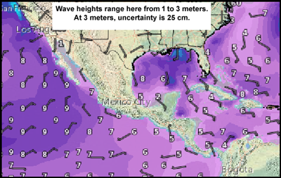
Why is this significant? They cannot calculate sea surface height without adjustment for the wave heights. Waves that range from almost-nothing to 20 meters. They think they can get a good idea of wave heights between 0.5m and 8m with a goal for uncertainty of “10 cm plus 5% of significant wave height”. Outside that range, apparently all bets are off. How much uncertainty is that if waves are 8 meters? That’s 10 cm plus 40 cm = 50 cm = 0.5 meter = about 20 inches. To be perfectly fair, that is +/- 50 cm. How is it that they adjust for that much uncertainty – a whole meter in unknown surface height? (Admittedly, not that exactly, that’s the bottom-to-top of the waves, the sea surface height is somewhere between.)
Bottom Line:
1. There is a new satellite up that, among other things, will measure sea level rise. It is in reality no more accurate than the previous sea level rise monitoring satellites, the Jason series, but it will continue the long-term effort begun in late 1992.
2. Sea Level changes measured by satellite and reported in single digit millimeters are the result of computational hubris:
Computational Hubris: “An inordinate and unjustified trust, or faith if you like, in the power of advanced computational machines and processes to produce highly accurate and extremely precise results from relatively inaccurate and imprecise, highly uncertain data using techniques and methods that have not been tested nor verified to be suited to, or sufficient for, the purpose.” — Kip Hansen
3. Satellite reported Sea Level Rise is not a measure of changes in the actual level of the sea surface – or sea surface height — or its rise or fall, at all. Quoting the Sea Level Research Group at the University of Colorado, which is headed by Steven Nerem:
“The term “global mean sea level” in the context of our research is defined as the area-weighted mean of all of the sea surface height anomalies measured by the altimeter in a single, 10-day satellite track repeat cycle. It can also be thought of as the “eustatic sea level.” The eustatic sea level is not a physical sea level (since the sea levels relative to local land surfaces vary depending on land motion and other factors), but it represents the level if all of the water in the oceans were contained in a single basin. Changes to this eustatic level are caused by changes in total ocean water mass (e.g., ice sheet runoff), changes in the size of the ocean basin (e.g., GIA), or density changes of the water (e.g., thermal expansion). The time series of the GMSL estimates over the TOPEX and Jason missions beginning in 1992 to the present indicates a mostly linear trend after correction for inter-mission biases between instruments.” [ source – see last paragraph ]
4. The 3.0 mm of satellite reported annual sea level rise does not show up as a rise in absolute mean sea level at the world’s GPS-corrected tide gauges which directly measure mean sea surface height at each location. (Absolute sea level represents the sea surface height relative to the center of the Earth – meaning an actual rising of the sea surface upwards.) This reality-based fact is as yet unexplained and is a controversial topic.
5. The ONLY sea level, or its rise or fall, of any importance to any locality or its governmental bodies is Local Relative Sea Level. This sea level rise (or fall) caused by rising absolute sea level rise combined with vertical land movement (in most instances, downward) determines the magnitude of any risk or threat from sea level rise for that location.
6. Many localities which have valuable infrastructure built on land only a few inches or feet above existing mean sea level for their location are already at risk of flooding by spring tides and storm surge and need to initiate changes in building codes and begin mitigation immediately. The sea will continue to rise, ever so slowly.
7. Finally, almost everything about sea level rise is controversial and readers should turn their critical thinking skills knob up to FULL when reading anything, including this essay, on the topic.
# # # # #
Author’s Comment:
Josh Willis’ comment to SciTech caught my attention. He said: “We can’t lose track of how much sea level has gone up because if we do, it’s hard to predict what’s going to happen in the decades to come.”
How would it be possible to “lose track” of sea level rise? The sea is just there. Sea level is where its surface hits the land all around the world. If it rises, we will see it rise. It is not something that is hidden and thus, if we turn our backs for a decade or so, can be lost track of. That is unless it is something so small and inconsequential that we’d miss it without satellites telling us that it is rising. As the metric GMSL-as-measured-by-NOAA is only 3 millimeters a year, wouldn’t it be enough to measure it once a decade? Then, ten years from now, we could expect to see a 30 mm rise – about 1.2 inches….and if it rose at an alarming 4 mm a year, 40 mm or 1.5 inches. And if SLR doubled? We’d see about 60 mm or 2.4 inches of rise.
That’s true only if satellite measured Eustatic Sea Level rise actually arrives at our shores, our harbors, our bays and inlets. To date, it hasn’t.
Unless you are just making a general comment, remember to say who you are talking to: Like “Kip, I think….”
Thanks for reading.
# # # # #