Today is a day of amazing weather contrast across the region, with unusual extremes around every corner.
On one hand, the low-level air over Washington State is extraordinarily dry, because frigid Arctic air has very little moisture content.
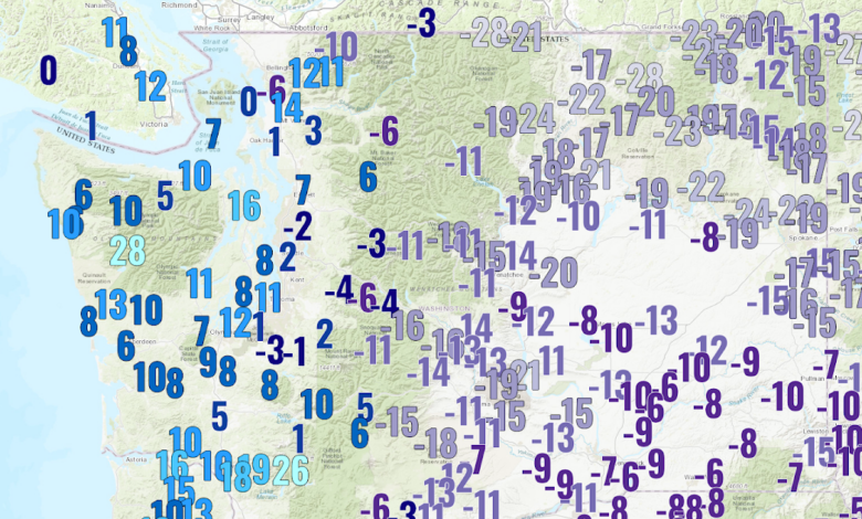
Consider dew point, an absolute measure of the water vapor content of the air.
Dew point temperature, the temperature to which air must be cooled to get saturation (100% relative humidity), is in the single digits to below zero F over much of the state (see plot below for 2 PM values).

In western Washington, wintertime dew point temperature is typically in the 30s or low 40s. To illustrate how unusual things are, below is a plot of the dew point temperature at the UW for the last twelve weeks.
The bottom has plummeted during the last few days, with a dew point near zero. Very dry air. In contrast, dew point is 36F right now at Khartoum, in the Sahara Desert.

Or perhaps you prefer relative humidity (RH), which tells you how close to saturation the air is (saturation is 100% RH). Below is the RH forecast for 4 PM today for the surface air. Quite low, with values in much of the state below 40%.

In contrast, relative humidity is far higher over Oregon, due to a moist weather system moving to our south (see the 2 PM visible satellite image below)

So the outside air over much of Washington is very dry.
But now the shocker….it is even DRIER inside our heated buildings.
Below is the indoor relative humidity around Seattle.
OMG. Many values are below 25% and some are in the teens. No wonder your mouth is dry and your skin is cracking!

Why such low relative humidities inside?
Relative humidity is 100 times the ratio of the amount of water vapor in air divided by the maximum amount it can hold.
Outside air is constantly invading our homes and buildings so the moisture content is pretty much the same inside and out. But the amount of water vapor air can hold depends on temperature and it is much warmer inside. Thus, relative humidity is much lower inside during the winter.
Blizzard over the Western Gorge
Finally, while a dry storm is hitting much of Washington State, strong easterly winds are found in the Columbia Gorge, hitting places such as Troutdale and Portland. At Crown Point, a scenic location in the western Gorge, winds are now gusting above 80 mph. These winds are being driven by a historic difference between eastern Washington (high pressure) and the coastal areas (with low pressure approaching from offshore).
Snow has now spread across northern Oregon, with areas of localized freezing rain. This was the wintry weather that was forecast to move into our region by the errant American weather model, the GFS.

Portland at 4 PM has a cover of snow