Will do an update tonight on the potential for lowland snow on Friday/Saturday.
_______________________________________________________
There is a LOT of active weather ahead, some of it very challenging to forecast.
If you had any plans on crossing the Cascades, do it today. Most of the passes will be closed by blizzard conditions tomorrow.
And I would charge up your phones and other electronics today if you live west of the Cascade Crest.
A strong wind event over the western lowlands will result in many power outages later tonight and tomorrow morning..
The key feature over the next 24-h will be a strong low-pressure center that will move across southern British Columbia tonight and tomorrow.
Check out the pressure/wind/temperature forecast for 7AM tomorrow morning (below). The solid lines are isobars…lines of constant pressure.

A very large pressure gradient (difference) will develop over Washington State and this will produce strong winds.
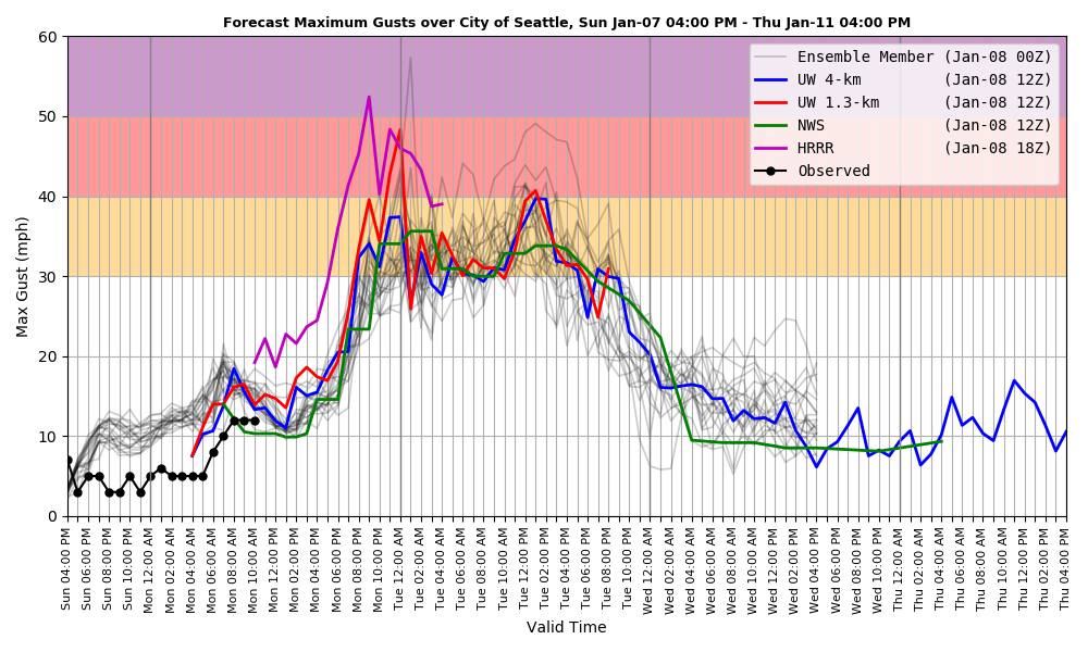
Let me show you the latest forecast from Seattle WindWatch, a sophisticated wind forecast system developed and run at the UW, with support from the city of Seattle.
This plot shows the maximum forecast gusts over Seattle from several prediction systems.
Wow. Wind this evening could easily hit 40+ mph in some Seattle locations, with winds remaining quite strong (from the south) all day tomorrow.
Strong winds will be observed over the entire lowlands for most of Tuesday morning, followed by a strong westerly wind surge down the Strait of Juan de Fuca around noon (see forecast of max wind gusts in knots at 1 PM Tuesday). Very strong winds along the coast and in the mountains.

And then there is the heavy snowfall in the mountains. The National Weather Service now has a blizzard warning out….a good call.

With the strong low to our north, there will be powerful westerly (from the west) winds ascending our regional mountains, with plenty of moisture in the flow.
The UW model is going for a huge snowfall over the Washington/Oregon Cascades, Olympics, and mountains of southwest BC, with over 3 feet at higher elevations (see snowfall total forecast through Wednesday morning)

Such snowfalls, pushed by mountain winds gusting to 40-60 mph, will produce highly dangerous conditions in the passes.
Don’t try it.
But very good for skiers in a few days.
Finally, there is the truly difficult forecast for Friday, where the potential for lowland snow looms.
I will discuss this situation in more detail in further blogs, but let me give you the bottom line.
It will be cold enough to snow in western Washington. The U.S. model has snow moving into western Washington on Friday afternoon and evening. The European Center model takes the precipitation to the south, leaving the Puget Sound region and NW Washington snow-free.