Tropical storm warnings were in effect for parts of Canada and a wide stretch of coastal New England on Friday as Hurricane Lee moved toward Canada, where it is expected to make landfall on Saturday.
New England is likely to experience weather similar to what occurs during a nor’easter, said Andrew Loconto, a meteorologist with the National Weather Service in Boston. During such storms, which typically occur in late fall and through the winter, large waves crash ashore and often flood coastal roads.
The tropical-storm-force winds extend far from the center of the storm and are expected to reach the coastline. But for areas inland, it is “going to be a pretty breezy day,” Mr. Loconto said.
However, leaves are still on many trees, and abundant rain over the last several weeks could make some areas more susceptible to wind damage. Jon Breed, a spokesman for Central Maine Power, said that soil erosion caused by record rainfall means trees are less securely rooted in the ground, which could lead to power outages.
Government leaders across New England and Canada have issued alerts and warnings anticipating the arrival of a powerful hurricane this weekend, though a small shift east or west will could make a significant difference in how damaging the storm will ultimately be.
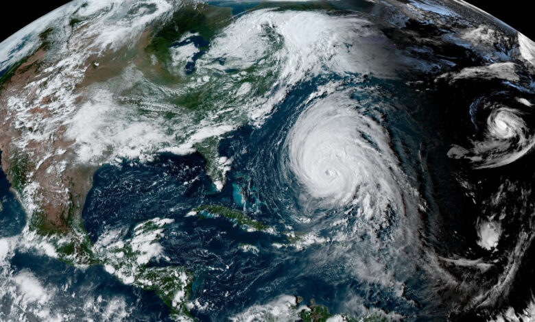
As of 11 a.m. on Friday, Lee was about 395 miles south-southeast of Nantucket, Mass. It had maximum sustained winds of 80 m.p.h., making it a Category 1 storm, and was moving north-northeast at 18 m.p.h. Though the storm is expected to weaken, the Hurricane Center said it would remain “near or just below hurricane force” as it approaches New England and Atlantic Canada.
These strongest winds are likely to occur over the Gulf of Maine and may affect portions of far northeastern Maine and Nova Scotia. Such winds can cause roof damage to homes, toppling trees and downing power lines.
With the strongest threat of the storm expected in Nova Scotia, the hurricane watch was discontinued for Maine, but a tropical storm warning still remains in place. Gov. Janet T. Mills of Maine declared a state of emergency on Thursday, and the White House ordered federal assistance to the state.
The Canadian Hurricane Center also extended a hurricane watch on Friday for part of the provinces of New Brunswick and Nova Scotia. The center said that its hurricane and tropical storm watches referred to conditions expected on Saturday.
A tropical storm warning, meaning winds of 39 miles per hour or higher are expected within about 36 hours or less, was in place from Westport, on the South Shore of Massachusetts, and the islands of Nantucket and Martha’s Vineyard through parts of New Brunswick and Nova Scotia in Canada. Forecasters warned that the growing size of the storm means hazards will extend well away from the center.
Friday night and into Saturday, Lee was expected to move past Cape Cod as a large hurricane. By Saturday afternoon Lee’s center will be very near the western end of Nova Scotia.
Officials in Boston were hopeful after Lee turned “slightly east” on Thursday morning.
“At this time, we are expecting the worst of it to miss Boston, which is good news,” said Mayor Michelle Wu of Boston at a news conference on Thursday. “Fingers crossed that will remain the projection.”
The city expects to receive four inches of rain with wind speeds up to 30 miles per hour as the storm arrives late on Friday evening and lasts through Saturday evening, Mayor Wu said.
The city of Quincy, Mass., just south of Boston, said it was installing floodgates on Thursday to close gaps in its sea wall.
Southampton, a town on the eastern tip of Long Island in New York that is threatened by high tides and coastal flooding, declared a state of emergency, beginning on Thursday and stretching through the weekend.
Anne Strauser, a meteorologist with the National Weather Service, said that the worst-case scenario for Maine would be if the storm shifts farther west and creates more onshore flow, which could make coastal flooding worse. She said that any storm surge that occurred there would vary depending on the tide cycle. Unlike when a hurricane makes landfall in the southern United States, and the tides vary by a few feet, the tide swings in Maine can be from eight to 18 feet. So a storm surge at low tide might not have much of an effect.
‘It’s just going to get wider.’
As the storm heads north, it will weaken as it moves over cooler water. And as it approaches land, it’s likely to transition from a tropical system — one that gets its energy from the ocean — into one similar to Hurricane Sandy’s, which drew energy from competing cold and warm air masses.
While weakening is good, it will not diminish the potential impact of wind, rain and coastal flooding. “This storm is already on the larger side for a hurricane in terms of how wide it is,” Ms. Strauser said. “And it’s just going to get wider as it moves north.”
In Canada, officials are concerned that because of Lee’s broadness, it is likely to affect most of the Maritime Provinces and parts of eastern Quebec.
Western Nova Scotia faces some of the highest possible impacts from Lee, Environment Canada said.
Sydney Cromwell, Johnny Diaz, Melina Delkic, Mike Ives, Orlando Mayorquin, Anastasia Marks, Eduardo Medina, Chris Stanford, John Yoon and Derrick Bryson Taylor contributed reporting.