It was setting up to be a case of disaster déjà vu for North Carolina.
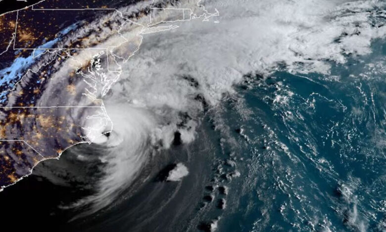
Less than a year removed from Hurricane Florence – our state’s wettest and costliest tropical system on record – a new storm reached Category-5 strength just to our south in early September of 2019.
The rapid strengthening of Hurricane Dorian as it approached the Bahamas, followed by its northward turn toward North Carolina, left many across the state fearing another catastrophic storm and preparing for that possibility.
In the days that followed, Dorian weakened as it neared our coastline, giving a glancing blow for most – but not all – of the state. That kept it out of our pantheon of recent large-scale disasters that includes Florence and Hurricane Matthew just three years prior in 2016.
But more than the damage it caused, Dorian is memorable in retrospect for how it tested the technological advancements, new preparedness measures, and even our collective mental well-being in post-Florence North Carolina.
Florence-Informed Preparations
The lead-up to Dorian five years ago was framed by the familiarity of those other recent hurricanes, and parts of the state still bore the scars from Florence, which hit less than eleven months prior. Camp Lejeune had sustained $3.6 billion in damage, and 200 to 300 buildings on the base were still patched with tarps when Dorian arrived.
But there was also an element of opportunity to test new ideas inspired by both Matthew and Florence, especially for the NC Department of Transportation (NCDOT), which had seen those previous storms inundate thousands of roads and leave miles of interstate underwater for more than a week.
Their preparations started immediately after Florence, with the help of ESP Associates – an engineering design and consulting firm with a specialty in stormwater and flood risk.
For David Key, the Water Business Unit Lead at ESP, the directive was clear and ambitious, particularly with such little lead time in the wake of Florence.
“We were told as a contractor of NCDOT that when the next storm happens, they need to know which roads are going to be underwater,” said Key, reflecting recently on his experience during Dorian.
That effort included consolidating three-dimensional maps of roads and linking them with storm surge prediction models driven by the National Hurricane Center’s official forecasts. The initial results were promising, but with one key uncertainty.
“Before Dorian, we had started doing some modeling of road inundation, but weren’t sure if it was accurate,” said Matt Lauffer, the State Hydraulics Engineer at NCDOT.

As Key and his team at ESP Associates prepared to create real-time flood forecasts and NCDOT awaited the chance to assess their accuracy, other groups across the state were implementing their own action plans, which in some cases received needed revisions after Florence.
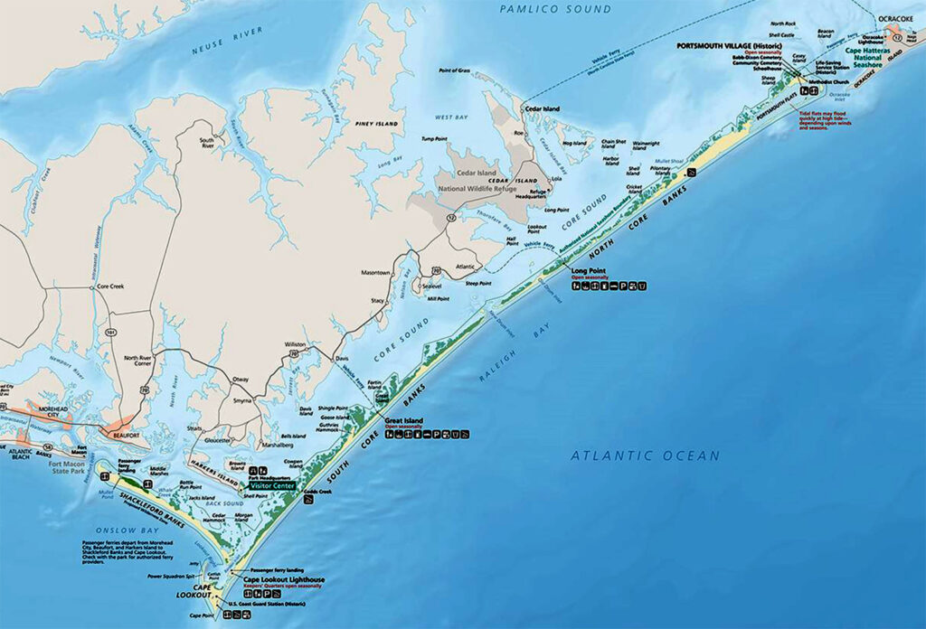
That included Cape Lookout National Seashore, which as a low-lying area along the central coastline had suffered significant flooding from Florence and was also in the likely path of Dorian’s eyewall as it moved up the coast.
Seashore Superintendent Jeff West said their previous 67-page response plan was of limited utility after Florence, both because it was rarely read and because it relied so heavily upon staff being able to respond immediately after an event. That was a challenge given the scale of the damage, from the power being out for up to 15 days to the widespread flooding that made just getting around difficult.
“For the initial assessment, we depended a lot on our people getting out in the boats and out on the banks to look at the resources we’d need to respond,” said West. “But we had a lot of employees with damage to their homes, and we had a lot of access issues, so we had to modify the plan almost immediately.”
In an after-action review following Florence, the plan was shortened to about 20 pages covering key actions and objectives that should be covered before, during, and after a storm. That would make for a more streamlined response, which was handy when Dorian delivered a surprising blow to the seashore.
The memories of those recent storms were also fresh for the state as they planned for potential evacuations ahead of Dorian. While counties typically open their own shelters, more impactful storms often require opening at least one larger state-operated shelter, which takes a coordinated effort between multiple agencies including NC Emergency Management, the Division of Public Health, and the NC Department of Agriculture and Consumer Services.
The latter group aids in a potentially unexpected way: helping pets, in addition to people, find safety amid a storm. Anna Allen is their Eastern Region Emergency Programs Veterinarian, and her job includes coordinating care for companion animals evacuating with their human families.
During Florence, that effort spanned across a pair of shelters in Chapel Hill and Winston-Salem, and the scale of that response informed the preparations as Dorian neared our doorstep.
“We had Matthew, then two years later we had Florence,” said Allen. “So we went a little big on our incident management team and our setup because we were really on edge.”
That setup included opening a shelter at the Northgate Mall in Durham with a capacity of 500 people, plus dozens of pets in Companion Animal Support Trailers that can park at and plug into the shelter buildings. Each trailer has room for 20 to 40 small animals.
It was a better-safe-than-sorry sort of approach, given that organizers never know exactly how many people – or pets – will show up at such a shelter.
“If a shelter that big actually gets that many people coming, we don’t know how many of those people are going to come with pets,” Allen added. “So there was a lot of nervous energy around this storm.”
The Storm Rolls Through
Despite paralleling our coastline like Matthew had done three years earlier, Dorian was a more compact storm that didn’t pull in as much moisture west of the eye, so it did not have the same widespread inland impacts, including flooding.
That meant the need for a centralized evacuation shelter was lower, and the Durham shelter wound up with just 12 people and four pets: two cats, one dog, and a photogenic guinea pig named Kisses, brought along by the Santiago family evacuating from Wilmington.
Considering the preparation that went into such a large shelter, which included calling in a national sheltering team from the ASPCA, it was a modest turnout at best.
“But we took very good care of these four little animals,” said Allen.

Elsewhere in the state, other animals were exposed to the elements, most notably on the storm-lashed coastline. That included a herd of cows and horses swept off of Cedar Island by the rising water. The 28 horses didn’t survive, but a trio of cows swam across a four-mile stretch of Core Sound and into Jeff West’s relative backyard on the Cape Lookout National Seashore.
That wasn’t his only surprise in the wake of the storm, which started with a sense of relief. Ocean-facing parts of the seashore and broader Outer Banks suffered relatively little damage, aside from some beach erosion and lost shingles and siding due to the wind.
“I’m thinking that wasn’t too bad, and the next morning after the storm I met one of my maintenance folks on Cedar Island to start checking North Core Banks,” West recalled.
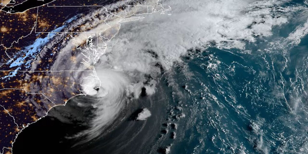
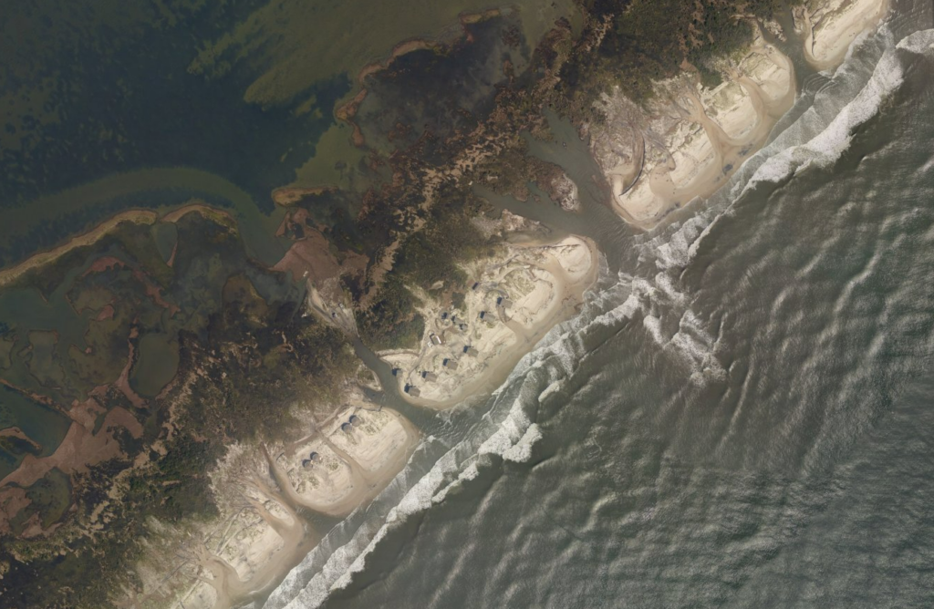
That’s when he discovered how incredible the flooding had been on that side of the coastline. As the Category-2 storm neared its landfall at Cape Hatteras on the morning of September 6, northeasterly winds wrapping around the eye created a sound-side storm surge like few in that area had ever seen.
“USGS says one of the swells that came across North Core Banks was nine feet tall,” said West. “That’s a massive amount of water with a tremendous amount of energy.”
It was enough to carry the cows into the sound. Enough to dump several feet of sand into the harbors of North Core Banks. And enough to cut several neck-deep-or-worse breaches through the narrow island.
West also discovered that the protective measures implemented after Florence to guard against a similar ocean-side impact – including a bulkhead designed to divert sand and water away from the harbors – had an unintended consequence during Dorian.
“When a sound-side event hit it from the backside, all it did was erode underneath the bulkhead, it dug a massive ditch, and dug out the wall completely,” he said. “It just wasn’t built for that impact.”
That meant 160 feet of pilings and beams washed away without a trace.
Other areas around the southern rim of the Pamlico Sound sustained the worst of the damage from Dorian due to the one-two punch of more than six inches of rain falling, followed by the wall of water entering unimpeded.
The small Pamlico County town of Oriental was inundated to a depth of almost five feet, per the National Hurricane Center’s report, and one of three storm-related fatalities in the state occurred there when a man pulling his boat out of the water had a heart attack.
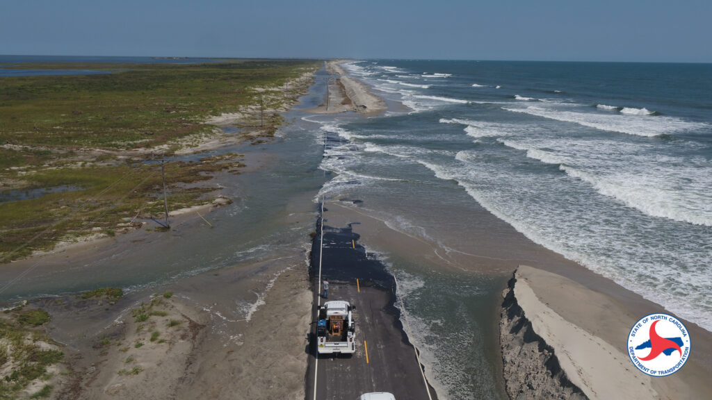
On remote Ocracoke Island, a 7.5-foot storm surge inundated the village and breached Highway 12, cutting off access to the Hatteras ferry terminal and effectively stranding the 800 or so residents on the island.
For several days, they had no power, no safe drinking water, and no access to the tiny town’s grocery store, bank, or health center. And Dorian left an estimated 400 of the 1,200 structures on the island severely damaged or uninhabitable.
NCDOT officials watched the storm play out from the state Emergency Operations Center in Raleigh, and the impacts to Ocracoke were hard to fathom.
“I was amazed to see how fast that surge wave came in, and how fast that island was impacted,” said Lauffer.
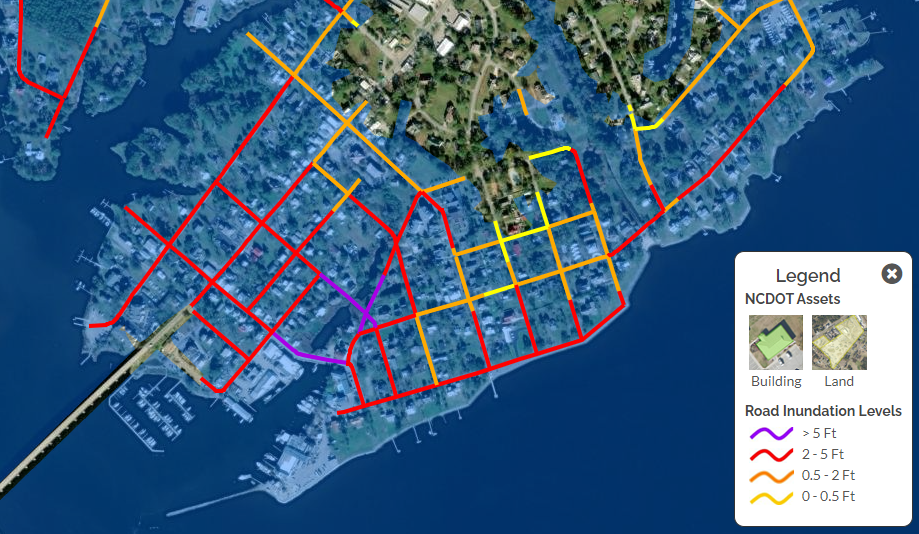
The field observations from Ocracoke and other areas during Dorian ultimately helped validate the flood model that Key and his team at ESP provided to NCDOT. And the verdict?
“We’ve come to find out it’s pretty accurate,” said Lauffer.
Indeed, the model had forecasted a five-foot inundation on the roads along the Oriental marina and widespread flooding to a depth of at least two feet throughout Ocracoke village and on the south end of Highway 12 on the island.
While Dorian may not have had the same widespread impact of Florence – retroactive surge forecasts showed 959 miles of coastal roads impacted, compared with 1,672 miles during Florence – it offered hope that those forecasts can better prepare local areas, no matter the severity or scale of a storm.
“If we can bring that information to them beforehand, that’s huge: in 24 hours, this is what your roads will look like,” said Lauffer in advertising the ongoing advancements over the past five years.
Up to the Task
A successful trial during Dorian encouraged NCDOT and ESP Associates to continue developing their forecast model, and it has now become part of an internal tool called T-SAPP: the Transportation Surge Analysis Prediction Program.
“Now they’ve got an elaborate website and distribution platform, but back then, I was just emailing Matt a Google Earth file,” said ESP’s Key.
In recent years, that system has undergone more tests and further refinements, which has also led to new applications. Flooding forecasts during Ian, Idalia, and Ophelia were used to better position resources along the coast, including by the Coast Guard as part of their response to hard-hit areas.
This summer during Debby, a suite of tools including T-SAPP, BridgeWatch, and FIMAN-T – a flood mapping and alert system based on a tool originally developed by NC Emergency Management – helped NCDOT’s operations staff manage the statewide traffic system, particularly along flood-prone stretches of Interstate 95 and US Highway 74.
Key says the timing of Dorian so soon after Florence helped keep the momentum going for the forecast model and tool development.
“The memories of Florence were really fresh for emergency responders and stakeholders, and everybody pushed themselves to do more with the data,” he said. “If we had skipped a couple of years until the next storm, we might have lost some of the will to get out front and do something on this.”
From Lauffer’s perspective, the stormy past decade has ultimately led to improved partnerships between NCDOT and ESP Associates, NC Emergency Management, the Department of Public Safety, and other agencies. Legislative funding has also helped build out the 3D roadway models and add more riverine gauges, which ensures more accurate and detailed model guidance.
“What you get is a more resilient, robust state that can recover quicker and better,” said Lauffer. “And that’s good for economic viability and saving lives.”
For groups such as the NC Department of Agriculture and Consumer Services who help plan and prepare evacuation shelters, Dorian was a learning opportunity, even if a shelter capable of handling hundreds of people only had a dozen – plus a few fuzzy friends – show up.
“It was a good exercise in our protocols and processes,” said Allen, who noted that because of turnover, new employees join state agencies each year who haven’t been through a storm, and events such as Dorian and Debby help them see how shelter planning and rescue operations work.
By now, Allen is a veteran veterinarian, having coordinated companion animal support for a number of storms over the past six years beginning with Florence. From her experience, she offered a few tips for pet owners who may need to evacuate amid an oncoming hurricane.
“If you’re going to take small animals, have as many things to care for them as you can if you go to a shelter,” she said.
That includes proof of vaccination – and in North Carolina, dogs, cats, and ferrets require rabies vaccination – along with a cage, food, leash, and collar that each animal is comfortable with. Any medications should come along as well.
For large animals such as horses, several private or state-owned facilities may open to shelter them, and moving them out of the path of a storm could be a life-saving decision given the infections that can develop if they stand in flood waters for prolonged periods.
Allen encouraged all animal owners to use blue-sky days to make a plan for how to best care for their pets amid a storm, since those busy hours ahead of a hurricane can be stressful for people and pets alike.
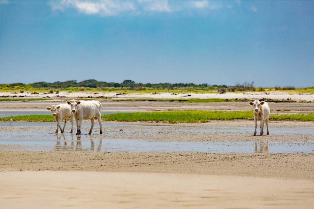
At Cape Lookout, the three animal survivors of Dorian’s storm surge were moved back to their home on Cedar Island, and one cow – appropriately named Dori – even had a healthy calf a few months later.
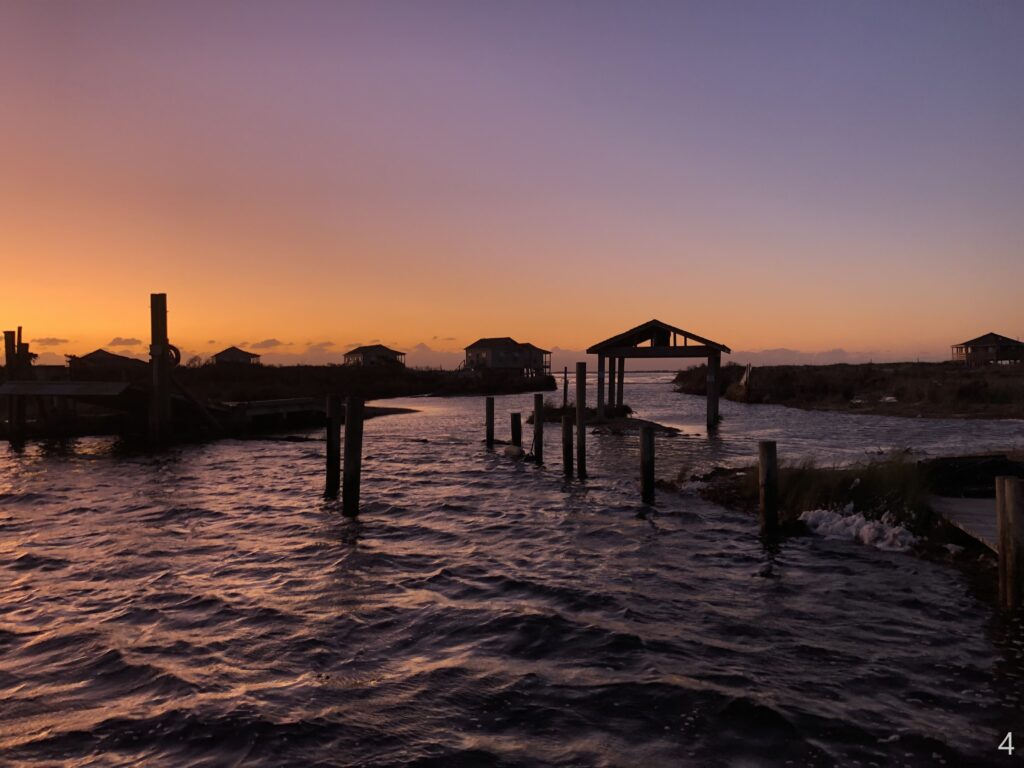
But it hasn’t all been good news. For West and his staff on the seashore, the years since Dorian have included some difficult decisions about where, or whether, to rebuild.
All 64 historic buildings in Portsmouth Village were damaged by Dorian, and a handful were completely destroyed. In addition, the popular Long Point Cabins on North Core Banks were damaged beyond the cost of repair.
Many of those buildings will not be rebuilt, which means a critical link to the past, as well as a key tourism draw, is being lost for these aging and isolated Down East communities.
For some people, West said, “it’s about feelings, not practicality. It caused a lot of angst among our visiting public to not have those cabins to stay in, and to have to demolish some of those historic structures.”
For structures that are being reconstructed, such as the cabins, West said the seashore has learned lessons from ocean-side events like Florence, sound-side storms such as Dorian, and even the Nor’easters that move up our coastline each winter.
After reviewing aerial photos of North Core Banks dating back the 1940s, West and his team identified areas that consistently had overwash during storm events, and used that to find the most sustainable locations.
“If we’re going to rebuild these cabins, why not put them in the highest area on the island with the best protection from oceanside surge that’s never had soundside overwash,” he said.
Current plans call for the cabins to be elevated on pilings and powered by solar and wind energy, with a backup generator available. The public water supply will use treated well water, and rather than installing a storm-vulnerable septic system, the new design has one sewage treatment system on an elevated platform. Of course, in this part of the state, elevation is a relative term.
“By a fair amount of elevation, I mean five feet,” said West, underscoring the challenge this part of the coast faces for the future.
A Forward-Looking Legacy
The shoreline today bears few obvious lasting impacts from Dorian. In the months after the storm, the traditional sandbars quickly reformed offshore, and almost all of the cut-throughs filled in to restore beach access. But during and since Dorian, one critical part of our coastline has continued to change.
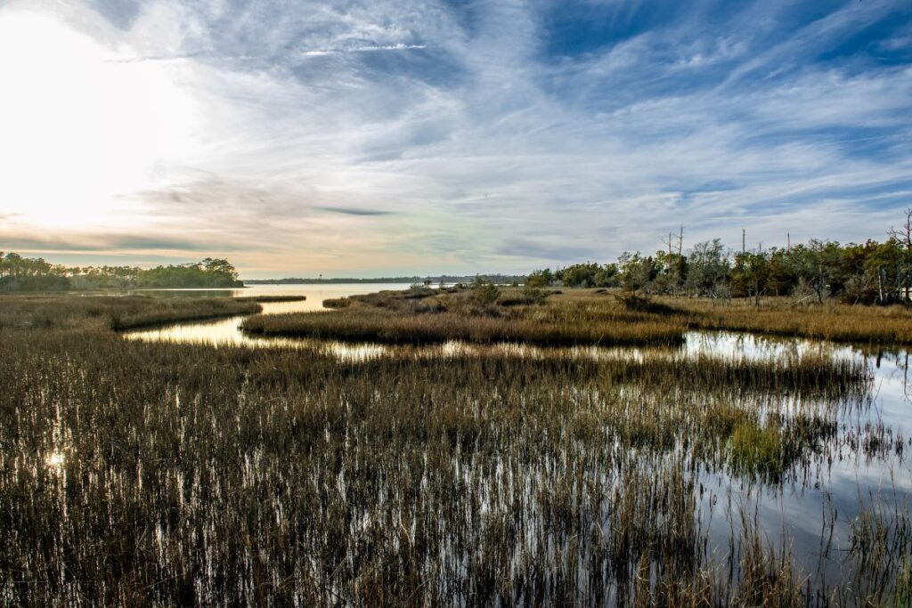
Salt marshes absorb wave energy and protect the land behind them from flooding and erosion, including during hurricanes. They also serve as nurseries for fish and crabs, bolstering both coastal ecosystems and the state’s seafood industry.
However, the combination of sea level rise due to climate change and repeated hits from tropical storms is endangering these salt marshes. One analysis of elevation trends in North Carolina’s coastal wetlands found that only 10 of 132 surveyed sites were gaining elevation fast enough from the deposition of sediment to keep pace with sea level rise.
West has applied for a project that would help protect and recover more than 1,500 acres of marsh at Cape Lookout, if it’s funded. The NC Coastal Federation has secured $30 million from EPA to do the same sort of work. But will it be enough?
“Storms are the wildcard in all of this,” said West. “You can do all the right things and have them canceled out in an instant.”
In that sense, West said that Dorian was an eye-opener, particularly as the storm surge carved up North Core Banks and tore through their well-intentioned wall.
While Dorian’s winds felt familiar as the storm brushed our coastline at Category-2 strength, the damage left behind stood out in its own way for West, who weathered Hurricane Andrew at a Nike missile base in the Everglades and drove a boat through New Orleans in the aftermath of Katrina.
“For an impact to something I’ve been responsible for, Dorian was a tear-jerker, heavy impact event,” he said.
“It’s one thing when you respond and try to bring order to chaos. It’s another thing when you’re responsible for something and put your blood, sweat, and tears into something, and you see literally overnight the whole thing destroyed.”
For some, Dorian’s legacy stands as an avenue of innovation – “a proof of concept of the dream that we had after Florence of never being caught by surprise again,” per David Key at ESP Associates on his flood modeling work with Matt Lauffer and NCDOT.
For others, Dorian was the first test of our preparations in the wake of Florence. In that sense, statewide shelter organizers like Anna Allen were overprepared and underwhelmed, but it was still a useful exercise to keep their staff and their partners ready for the next big one.
And for those eastern areas in the path of Dorian’s brutal storm surge, it was the next big one – and five years later, the last big one – that is still remembered for the wall of water that swamped sound-side communities, irreparably damaged well-loved buildings, and sent cows swimming in search of safety.