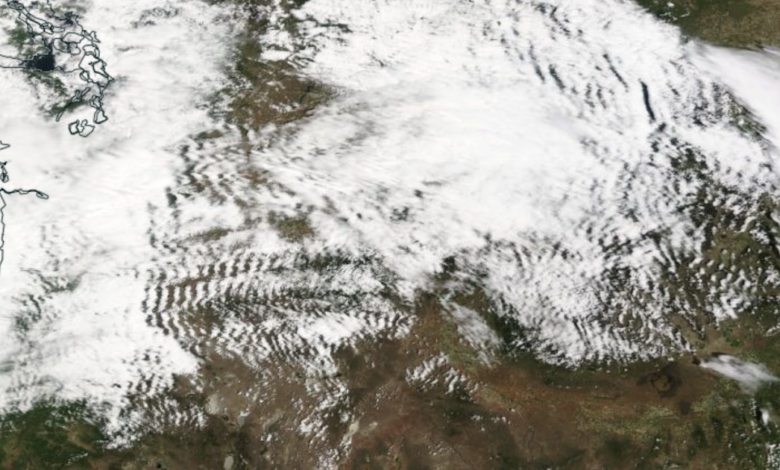
The high-resolution MODIS satellite image taken mid-day yesterday was remarkable, with extensive wave-like cloud formation east of the Cascade crest in Washington and Oregon (see below). More waves in Montana too.

Here’s a closer look at the waves in eastern Oregon. Features are very regular with north-south cloud lines and clear zones between them.

In southern Washington, there are still periods of clouds but they are distorted east of Mt. Rainier into a “v” shape.

What is going on here?
You are looking at mountain lee clouds or, more accurately, trapped lee clouds. You’ll learn about the “stuck” business in a moment.
When air approaches a mountain barrier with sufficient wind speed and under stable conditions, the air will be pushed up by the mountains and then oscillate up and down downwind of the terrain (on the leeward side). Think of a swing – you give it a push and the swing swings back and forth for a while.
As air rises, it cools (moving to lower pressure causes the air to expand and cool), which can cause the air to become saturated (cool air can hold less water vapor warm air). leads to cloud formation. So one can get a series of clouds with clear zones in between (where the air sinks) downwind of the mountain barrier.

Mountain waves are stronger in the lower atmosphere and weaken with altitude. Thus, they are “trapped” in the lower atmosphere downwind of the mountain barrier.
If the mountain barrier is an elongated linear feature oriented north-south (like the Cascades), there will eventually be north-south cloud lines and clear zones downstream of the barrier. Exactly, what we see downstream of the north-south Cascades.
If the barrier is more isolated, the mountain wave clouds look more like the shape of a ship (see below). Mountain wave clouds downstream of Mt. Rainier looks like “ship wake” clouds.

Can high-resolution weather forecast models accurately simulate and forecast such waves?
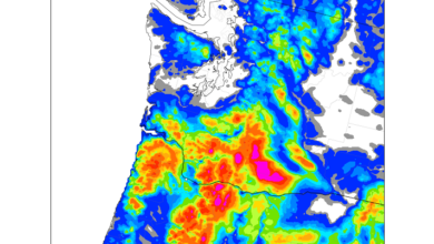
I am proud to say that the answer is definitely yes. Below is the nine-hour forecast of the cloud field from the UW ultra-high resolution WRF prediction model (the kind of work I do in my real job) at 2pm yesterday.
OH. Near perfect.

Trapped leeward mountain wave clouds are popular destinations for glider pilots, who try to maintain the upward motion of the clouds. Free vertical lifts courtesy of Mother Nature!