Why We Must “Quit Worrying About Uncertainty in Sea Level Projections” – Watts Up With That?

This commentary was first published by the CO2 Coalition, December 3, 2021
Opinion by Kip Hansen – 2 December 2021
Member – The CO2 Coalition
Jeremy Bassis, an Associate Professor in the Department of Climate and Space Sciences, University of Michigan, Ann Arbor, recently published an Opinion piece in EOS , a science news magazine published by AGU (American Geophysical Union), titled “Quit Worrying About Uncertainty in Sea Level Projections”.
It is an interesting read but not because it presents good advice to the scientific community. Rather, it presents the case that climate and ice models, which are used to make projections, are not up to the task. While those who program climate models have been trained in what we know about the basic physics involved in the biggest sea level rise issue – ice sheet dynamics – the actual projections by those models depend on parameters that are loose guesses about things we don’t know. As a result, Bassis says “…recent studies using climate and ice sheet models are, more and more often, coming to very different conclusions about future rates of sea level rise and even about the sensitivity of ice sheets to future warming…” and because of that, he tells us:
“Large discrepancies among model projections of long-term sea level rise have spawned calls among the scientific community for scientists to work on reducing uncertainty. However, focusing on uncertainty is a trap we must avoid. Instead, we should focus on the adaptation decisions we can already make on the basis of current models and communicating and building confidence in models for longer-term decisions.”
I agree in part with Bassis on one major point: “we should focus on the adaptation decisions we can already make”. But I strongly disagree that these decisions should be based on current models and their outputs. It is not that I think differently than Bassis about the problems of the models, they have problems galore. If one reads Bassis’ opinion just to understand why the models perform so badly, one will have gained something useful.
My disagreement comes from a different angle: Today’s observational data about global sea level rise itself reveals sharp disagreement between sea level research groups and measurement methods. NOAA says tide gauge records for the U.S. tell us the global absolute sea level rise for the 20th century has been 1.7 mm/yr. NASA’s satellite measurements claim 3.4 or more mm/yr, about double NOAA’s figure. Simply put, there is vast uncertainty about how much the sea has risen this year, last year and the last 50 years….we don’t need to look to the future for uncertainty about sea level rise.
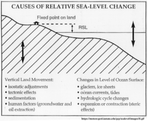
The only truly dependable measure of sea level rise is that obtained from tide gauges – these gauges reliably tell us what the height of the water’s surface is compared to the land to which the tide gauge is attached. That measurement is called local Relative Sea Level (RSL). All RSL is local and strictly speaking applies only to the single point at which it was measured.
The only sea level of concern to ports, municipalities, states and their governments, planning committees, city engineers and port authorities is Relative Sea Level measured at their precise location. That RSL is reality – it is a fact – it is really happening, right there, right now. The historical record of that RSL for that location is also reality – it is their reality – those past RSL measurements are also facts, they happened. Of course, historical records were created using less precise tools than current measurements, but they are the best we have and while they lack some of the precision of modern tide gauge records, they are generally dependable and represent data that informs us of the magnitude of that locality’s RSL changes reliably.
Thus, using reliable data of changes in RSL — comparing observations of the present to observations of the past — local authorities can easily predict short- and medium-term changes in sea level for their locality. That fact is based on simple physics – the water level of the world’s oceans is not capable of rapid, decadal-scale changes which would overwhelm local sea level dynamics. So, with reliable predictions of future local Relative Sea Level rise, localities can and should plan and carry-out sensible no-regrets adaptation measures based on the factual changes, past and present, of sea level at their port, city, county or state.
In order to make sure that the adaptation carried out is addressed to the right problem, that it is solving the right problem, more data is required.
And globally?
One would think that if we looked at all the tide gauges of the world and combined all their measurements in some manner this would tell is how quickly and by how much Global Sea Level is rising. Unfortunately, that is not the case. Why? It is because tide gauges measure that all important metric local Relative Sea Level – the point at which the water’s surface hits the land. So, if the water rises (as it does every tidal cycle and every time a storm hits and the wind blows), RSL sees a rise. Likewise, if the land (or the pier or seawall to which the tide gauge is attached) subsides (moves closer to the center of the earth), RSL also sees a rise. And if the land rises up, as it does in Alaska, RSL falls. This relationship simply means that we cannot determine changes in the actual level of the sea – the distance of its surface to the center of the earth — unless we know if, how much and in what direction the land itself (or the dock, pier, or whatever structure to which the tide gauge is attached) is moving.
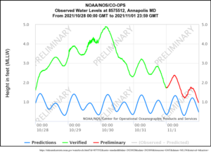
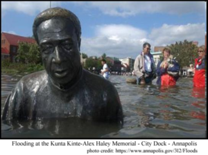
The recent flooding of the City Dock area of Annapolis in Maryland gives us an educational example. It was caused by exceptional tides at the end of October 2021 (see tide chart several paragraphs above). This area of Annapolis floods every time there is an unusually high tide. Why? … because it is mere inches above normal high tides for the area. The media blames this on climate change induced sea level rise. However, global sea level rise did not inspire Annapolis to build this iconic shopping area only a few inches above its normal tides. Nor did global sea level add much to their current problem. How do we know?
NOAA’s CORS Network supplies the data we need. Using GPS stations, running continuously for years, the CORS Network is able to discover the long-term movement of land masses and of specific locations (such as the structures to which tide gauges are attached). These CORS stations can measure movement in three dimensions – North and South, East and West, and up and down. The up and down measurement is called Vertical Land Movement (VLM). It takes years of CORS measurements to determine real long-term trends. Knowing VLM then, allows us to know “how the sea level is changing in relation to vertical motion on land.” [ see previous link ]
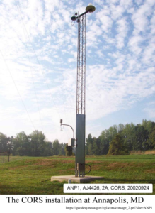
For Annapolis? The calculated rate of long-term Relative Sea Level Rise at the tide gauge for Annapolis is 3.71 mm/year or 1.22 feet in 100 years. Using continuously operating GPS reference stations (CORS), Richard Snay and his team at the U.S. National Geodetic Survey found that Annapolis and surrounding areas are subsiding, sinking towards the center of the earth, at a rate of 3.05 mm/year or about 1 foot in 100 years. [ref: Snay et al. (2007)]
Simple subtraction informs us that the absolute rise in the sea’s surface at Annapolis – how much higher the surface of the sea is from the center of the earth – has been only about 0.66 mm/year. That 0.66 mm/year is equal to 66 mm/century or 2.6 inches – in 100 years.
[ Per year that is 26/1000ths of an inch or ½ the thickness of U.S. dime (ten cent piece) each year – not totally inconsequential, but nearly so. ]
So, what happened to the 1.7 mm/year or the 3.4 mm/year of NOAA’s and NASA’s Global Sea Level Rise? We don’t know. Neither of those amounts of absolute sea level rise – increase in the height of the surface of the sea – actually arrived at Annapolis. The same is true for many other ports. The tide gauge at The Battery, at New York City, shows a RSL rise of about 11 inches over the last 100 years – but it is subsiding at 1.35 mm/year. Only 6 inches of the century’s rise is due to a rise in the absolute sea surface height.
This is repeated all over the world. Tide gauges have been used to calculate global absolute sea level rise but are not suitable for the task – they give erroneous results when perceived as global Sea Level Trends.
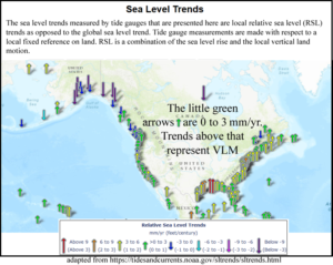
Unless…. unless they are corrected for the VLM of the actual structure to which the tide gauge itself is attached. Only then do you have a sufficient ground truth to know how much of the observable local Relative Sea Level rise (or fall) is due to VLM and how much is due to absolute sea level rise. Even then, you only really know for that specific location. We also know, once this correction has been performed, the causes involved and the magnitude of each cause – for Annapolis, four-fifths of their sea level rise problem is subsidence, the land sinking. For Annapolis to concentrate their policy efforts on reducing fossil fuel use to slow climate change and thus avoid increased high tide flooding is nonsensical. Their real problems are low elevation of waterfront properties (compared to water levels) and subsidence (which may not be solvable). The actual rise of the sea there over the last 100 years is less than three inches and that portion of the RSL rise could be mitigated by a single row of red bricks laid on edge (3½“) or a normal street curb (6”).
I fully agree with Bassis that we don’t have to worry about the uncertainty in sea level projections whether generated by models or from expert solicitation. But we certainly do have to worry about our uncertainty about sea level – today’s sea level – and its rise or fall over the last century, the knowledge which is needed to inform us about what to expect in the future. Satellite derived absolute or eustatic sea level rise is simply not appearing in reality – not appearing where the sea meets the land. Even NOAA’s and PSMSL’s tide gauge measured sea level rise is not appearing in reality – as actual rising sea surface – when it has not been corrected for VLM, ideally by Continuously Operating Reference Stations (CORS) attached to the same structure as the tide gauge (GPS@TG(ss)).
What the world needs is accurate actionable local data on their own local relative sea level rise and its contributing components so that they can come up with sensible no-regrets adaptation plans for their locality.
NOAA and its National Geodetic Survey CORS group along with the contributors to the Permanent Service for Mean Sea Level know what is needed to gather and process that data. They need more funding and more support from their respective governments to speed the installation (and maintenance) of Continuously Operating Reference Stations installed on the same structures as long-term operating tide gauges. Only when there are adequate numbers of these GPS@TG(ss) stations evenly geographically distributed will we be able to obtain an adequate understanding of global sea level rise derived from ground-truthed facts – not models that depend on parameterization or fabulously processed and adjusted space-based proxy measurements.
Author’s Comment:
I am not a sea level rise denier – the seas are rising and have been since the end of the Little Ice Age – at somewhere between 8 and 10 inches per century (maybe). Some places are in big trouble already. Other places are not. The biggest factors are geology and history.
Pragmatically, localities need to concentrate on their own problems and solutions. No matter what my little town does to mitigate global warming, it will not solve our problems along our tidal waterfront – ever. We need to solve our local problem locally. You do too.
But first, you have to have a true understanding of your local problems and possible solutions. For that, you need accurate facts – reality-based facts.
It may seem odd to you (it was to me) to demand reality-based facts. You may have been under the misguided belief that facts, by their very nature, were already reality-based. That, however, is no longer true, not even in the sciences.
Thanks for reading.
Kip Hansen is an expert on sea level and sea-level rise. Prolific author of numerous articles on the subjects. WUWT lists 445 commentaries and articles.
He has spent much of his adult life at sea, first as an officer on a merchant ship, and later as a USCG-licensed captain in the Caribbean, where he sailed with his wife while doing humanitarian work (mostly Dominican Republic).
He is a proud member of the CO2 Coalition.
This commentary was first published by the CO2 Coalition, December 3, 2021