Rain is coming to the Northwest during the driest time of the year
Every meteorologist knows that climatology provides only typical or average conditions and that natural atmospheric variability can produce some large variations from normal conditions.
That will certainly be true next week. Climatically, the last week of July is the driest time of year in western Washington (see map at SeaTac below). A great time of year to plan a barbecue or outdoor wedding.
But this year, the last week of July will bring rain… and even very heavy rain in some places.
I will show you.
The weekend will be generally dry, but a rain system will move in Sunday night/Monday morning.
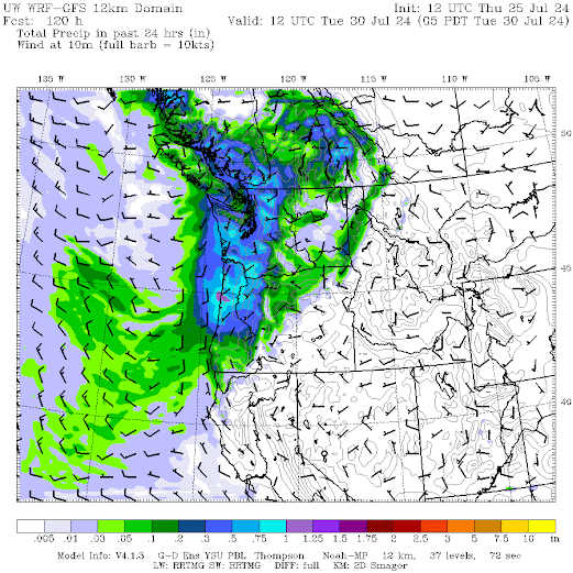
24-hour rainfall totals through 5 a.m. Monday show plenty of rain along the coast, with moisture spreading into northwest Washington.
Rainfall totals for the next 24 hours ending 5am Tuesday morning show western Oregon and Washington thoroughly drenched with up to half an inch of rain. A lot for this time of year. Even eastern WA got some.
And light rain will continue until Tuesday.
How sure are we about this rain?
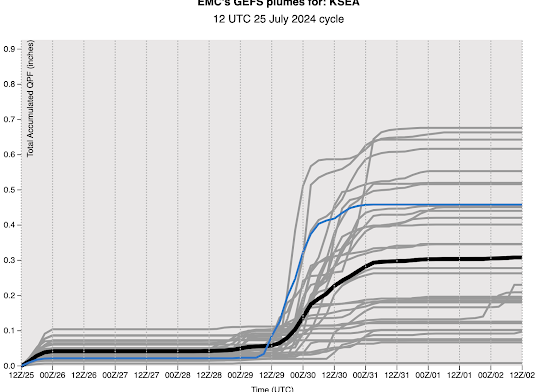
Consider a set of multiple predictions of cumulative rainfall in Seattle over the next week using the National Weather Service’s GFS model. Each gray line is a different forecast, with the blue line being the high-resolution forecast. There is considerable variability (and therefore uncertainty), but almost all of the forecasts predict rain.
And don’t forget the temperature. The highly accurate Weather.com website predicts a high of not even 70 degrees on Monday (see below).
This cool/wet period will have less thunderstorm activity and will help reduce subsequent wildfire activity.


