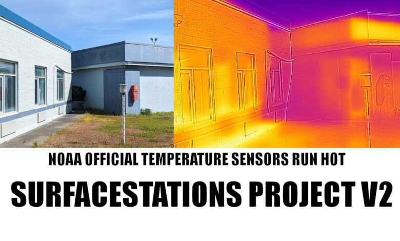
As many longtime readers of WUWT know, what brought this website to fame was the original surfacestations project done in 2007, 2008, and 2009. The exposure of the shoddy state of NOAA’s Cooperative Observer Network, and specifically its subset network the U.S. Historical Climatological Network (USHCN) caused quite a bit of consternation and embarrasment to NOAA as well as other agencies using the data such as NASA GISS, CRU in Britain, and others.
Since the publication of my How Not to Measure Temperature series and the subsequent booklet, NOAA has since disbanded the USHCN and no longer uses it in their National Temperature Index:
Please note: National USHCN monthly temperature updates have been discontinued. The official CONUS temperature record is now based upon nClimDiv. USHCN data for January 1895 to August 2012 will remain available for historical comparison.
https://www.ncei.noaa.gov/access/monitoring/national-temperature-index/
But they still use the data, they just don’t label it “USHCN.” Instead NOAA is favoring the “U.S. Climate Divisions” method, most likely due to the fact that we proved the USHCN network to be shoddily managed and unreliable. We reported back in 2012 that USHCN had been abandoned and Andy May did an analysis of the change, citing this passage from here, by NOAA:
“The switch [from USCHN] to nClimDiv has little effect on the average national temperature trend or on relative rankings for individual years, because the new dataset uses the same set of algorithms and corrections applied in the production of the USHCN v2.5 dataset. However, although both the USHCN v2.5 and nClimDiv yield comparable trends, the finer resolution dataset more explicitly accounts for variations in topography (e.g., mountainous areas). Therefore, the baseline temperature, to which the national temperature anomaly is applied, is cooler for nClimDiv than for USHCN v2.5. This new baseline affects anomalies for all years equally, and thus does not alter our understanding of trends.”
But, NOAA no longer had the public relations problem of refering to the compromised and embarrasing USHCN as nClimDiv became a new faceless dataset.
But many of those shoddy climate monitoring stations in the COOP network and USHCN remain open, and they are still used in the nClimDiv dataset either as primary stations or as stations used in pairwise comparisons for homogenization of the surface temperature record.
The bias effects of the poorly sited stations on the entire record is very clear, as I reported in 2015 at AGU.

Over a decade later since first starting the project, I want to find out what has changed, and how many stations have actually closed, gotten better, or gotten worse. So, I’m asking for your help again, to find and photograph those stations. We know some of the worst-case stations I embrassed them with have been closed.
Remember Marysville, CA, the poster child for bad station siting? It was the station that gave me my “light bulb moment” on the issue of station siting. Here is a photo I took in May 2007:
![marysville_badsiting[1]](http://wattsupwiththat.files.wordpress.com/2014/06/marysville_badsiting1.jpg)
It was closed just a couple of months after I introduced it to the world as the prime example of “How not to measure temperature”. The MMTS sensor was in a parking lot, with hot air from a/c units from the nearby electronics sheds for the cell phone tower:

Another equally bad USHCN station has been closed, Tuczon Arizona, which was measuring climate change in the parking lot in front of the Atmospheric sciences building at the University of Arizona, Figure 4.

So, I want to find out what the state of the current surface temperature network is, and I need your help to do it. In the past three weeks, I have been traveling in California, Nevada, Idaho, Oregon, and Montana to look at some of the USHCN and COOP stations. What I’ve found so far on my sample suggests that in both the COOP and the USHCN, about 95% of the stations are compromised in some way and do not adhere to NOAA’s published siting standards, allowing a temperature bias to be part of the data. This has been proven by NOAA itself in a peer reviewed study, and vindicates me.
I’ve already found stations just as bad as before.
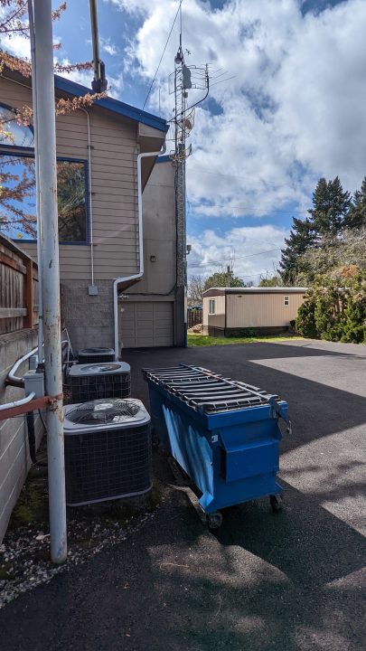
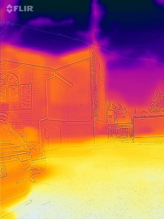
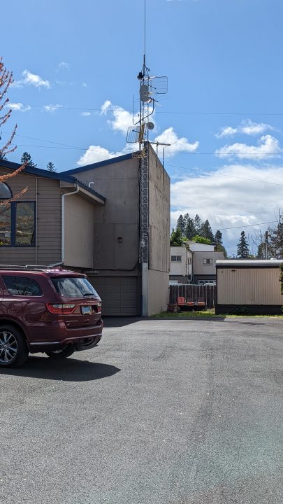
This is the USHCN station in Grants Pass, OR. Parking lots and air conditioners again.

The worst part? NOAA/NWS knows about it and doesn’t care. I received this comment on my Facebook page:
As the former Engineering Director there for 13 years I can say more than once when the Medford NWS office visited I asked if it could be moved to more suitable position. I even offered to do it. But the suggestion was always declined.
https://www.facebook.com/anthony.watts.chico/posts/5114537851927946?comment_id=5114579285257136
How can I help?
Well, it’s pretty simple, all you need is a cellphone (smartphone) and a web browser. If you really want to science it up, get a FLIR camera attachment for your phone.
Back in the day when I started the project, locating the stations was quite difficult. To NOAA’s credit, they have greatly improved the metadata for all surface stations an have a comprehensive database called the Historical Observing Metadata Repository (HOMR). In that database, you can find all the stations exact latitude/longitude, though they don’t give street address. Finding it on a map only requires Google Earth and dropping in the lat/lon values. Then you just drive there and look for it. Sometimes, you can even find them on Google Earth Street View.
So, I’m asking that wherever you live, you choose a station or two from the list below near you, announce it here in comments (to prevent doubling up), and follow the procedure I’ve listed below. Then post your photographs and description here, as well as emailing them as a zip file to me for inclusion in the database.
Here is the list of stations and their locations that I need to examine before the end of May 2022. These stations were included in my 2009 report IS THE U.S. SURFACE TEMPERATURE RECORD RELIABLE? Stations with line through them have either been closed or I have already surveyed them or plan to survey them. I have helpfully included a link to each one to the HOMR database that shows location. I’ve also included some notes on each station. You can see original photos of these stations in the original report in 2009.
Please see the procedure after the list on how to find and photograph them today.
Amherst, MA – Sewage Treatment Plant, 1 Mullins Way Amherst, MA 01002 GE LinkArdmore, OK – CLOSED 2009 for temperature reporting due to horrible siting on street GE Link
Ashland, OR – Sewage Treatment Plant, 1295 Oak St, Ashland, OR 97520 GE LINK
Atchison, KS – Benedictine College, 1020 N 2nd St, may be in courtyard GE LINK Baltimore, MD – CLOSED for temperature reporting due to horrible siting on roof.Bainbridge, GA – CLOSED 2010, sensor 8′ from road and A/C unit
Bartow, FL – Previously at P.D., sensor right on the street, MOVED. GE LINK Street View
Blacksburg, VA Located at NWS Office, 1750 Forecast Drive, in the rear GE LINK Street View
Block Island, RI – Original Report showed ASOS, HOMR element data shows a CRS, Find it please.
Brinkley, AR – Sewage Treatment Plant, 1185 Rusher Dr, Brinkley, AR 72021 GE Link
Brookville, IN – Brookville Water Works on Driveway, 898 Cliff St, Brookville, Indiana GE LINK
Buffalo Bill Dam, WY – May not be at vistor center, 4808 N Fork Hwy, Cody, WY 82414 GE LinkBunkie, LA – Surveyed already Sewage Treatment Plant. GE Street View LinkChampion, MI – CLOSED in 2011 due to location near parking lot. GE Street view Link
Clarksville, TN – at the WWTP off Quarry Rd. Lots of construction since original survey. GE LinkConway, SC – CLOSED, fire station closed, no new observer found.
Cornwall, VT – 2900 Seth Warner Memorial Hwy (private residence, visible from road) GE Street View Link
Crosby, ND – 209 1st Ave NW, Crosby, ND 58730 (private residence, visible from road) GE Link
Dayton, WA – Sewage Treatment Plant, Stockton Rd. GE Link
Detroit Lakes, MN – At KLDM radio, (moved 70′ west) 1060 Richwood Rd, Detroit Lakes, MN – GE LinkDillon, MT – Surveyed by A. Watts April 2022 Right next to campus generator bld, above sidewal – GE LINKDrain, OR – Surveyed already – A. Watts Sewage Treatment Plant, Division Ave, Drain, OR GE Link
Durham, NH – US Forest Service, W End Path, 271 Mast Rd, Durham, NH 03824 GE Link
Ennis, MT – Rainbow Valley Lodge, Hwy 287, Ennis MT GE Link
Enosburg Falls, VT Looks to be on a farm, 27-1 Birch Ln Enosburg Falls, VT GE LINKFalls Village, CT – CLOSED – went to automated SCADA data?
Fort Morgan, CO – MOVED in 2017 and 2018. May now be at private residence. GE LINK
Fort Scott, KS – MOVED 2013 from Funderal Home to PRIVATE RESIDENCE – 1904 S. Margrave St, GE LINKGainesville, GA – Observer died in 2021, station disposition uncertain, 955 Sunset Blvd. GE Street ViewGrace, Idaho – Surveyed by A. Watts April 2022, over concrete, bizarre placment of MMTS. GE LinkGreenville, TX – Surveyed already.Greenwood, DE CLOSED – Unknown reason GE Link
Gunnison, CO – At Gunnison County Electric Association near maintenance. GE Link GE Street View
Haskell, TX – Moved from radio station, at private residence now. 900 N 8th St, GE Link GE Street View Hay Springs, NE – CLOSED in 2018, directly next to building. GE Link GE Street View
Hendersonville, NC – Still at WKHP radio next to satellite dish, road. GE LINK GE Street View
Heppner, OR – Looks to be right on the street, at oil facility. 776-650 Riverside Ave. Heppner, OR GE Link
Hillsdale, MI – At Wastewater Treatment Plant. W Galloway Dr, Hillsdale, GE Link
Hopkinsville, KY – Moved 2020 from ridiculous location at BBQ/AC 302 Briarwood Dr. GE Street View Link
Hot Springs, SD – Looks to be next to parking lot, 501-599 N 5th St, Hot Springs, SD GE Link
Kennebec, SD – Looks to be in yard near garden, visible from 2nd street GE LinkLampasas, Texas CLOSED 2013 for temperature reporting due to horrible siting on street GE Street View
Lebanon, MO – At KJEL-FM next to parking lot. 18553 Gentry Road, Lebanon, MO GE Link
Lenoir, NC – On the sidewalk at City Municipal Bld. 605 Harper Ave. GE link GE Street View
Lexington, VA -Looks to be at residence at 298-126 Walker St. GE LinkLogan, IA – at Sewage Treatment plant, CLOSED in 2021, Lovelock, NV – Already surveyed.Marengo, IL – Sewage Treatment 1400 N State St CLOSED in 2019, equipment may still be there. GE LinkMarysville, CA Terrible location. CLOSED. Removed from service. Miami, AZ – Terrible location. CLOSED. Removed from service due to “data default” in 2008.
Midland, MI – Sewage Treatment Plant, Kent Ct. Midland. Sensor recently moved. GE Link
Milwaukee, WI Sewage Treatment Plant, 501 Sentry Dr. Wakesha, GE Link
Mohonk Lake, NY Huguenot Dr New Paltz, NY GE Link
Monticello, MS – Municipal Bldg. 317 Main St. GE Link GE Street View
Morrison, IL – Sewage Treatment Plant, 503 W Winfield St. Near SW fence border? GE Link
Mount Vernon, IN – Municpal Bldg. College and Water St. GE LinkNapoleon, OH – CLOSED, Sewage Plant, terrible siting GE Link
Neosho, MO at Neosho National Fish Hatchery 700 E, McKinney GE Link GE Street ViewNorthfield, VT – CLOSED, Sewage plant, observer quit, GE LinkOkemah, OK – CLOSED, unlocatable
Orangeburg, SC – Sewage treatment plant, 395 Seaboard St NW, GE LINKOrland, CA – Surveyed by A. Watts May 2022, still a good station. GE LINKOrono, ME – CLOSED 2008, ridiculous siting on roof of steam generator plant. GE LINK GE Street View
Panguitch, UT – Moved 2009 and in 2022, near house with watered lawn. GE Street View
Paris, IL – Sewage Plant, Near S. Fence 50’s of road and sewage tank GE Link GE Street View
Paso Robles, CA – terrible siting at the off-ramp for Highway 101 over concrete, still open. GE Street View
Pocahontas, AR – Residence, 106 E. Wiley St. GE Link GE Street View
Racine, WI Sewage Treatment Plant, 417 21st St. In front of office near parking. GE Link
Red Cloud, NE – City Garage? 763 US-281, looks to be on W side rear of building. GE Link
Assumption Richardton Abbey, ND – 418 3rd Ave W, could be at maintenance bldg. GE Link
Rock Rapids, IA – Municipal Bldg. Between Street and Parking lot. GE Link GE Street ViewSalisbury, MD – CLOSED 2011, Sewage Treatment Plant GE Street View
Sandpoint, ID Formerly Ag Exp. Station, now at Airport Granite Aviation 2099 Industrial Dr, appears to be next to tarmac. GE Link GE Street ViewSanta Rosa, NM CLOSED, terrible siting in observers backyard. GE Link
Searchlight, NV – Highway maintence facility, 320 NV-164, changed to MMTS 2011. GE Link Street View
Spanish Fork, UT Electric Substation, 2129 E. Powerhouse Rd. behind office near concrete wall? GE Link
Spooner, WI – Ag Research Station, out front. GE Link GE Street View.
St. George, UT – MOVED 2015 to private residence, original was sited in parking lot. GE LinkSt. Joseph, LA – Already surveyed.
State College, PA Unchanged from 2008, CRS behind Walker science building on grass GE LINK
Staunton, VA – Unchanged from survey in 2009, GE LINK
Tarboro, NC – Sewage treatment plant, unchanged from 2008. GE LINK
Thompson, UT – behind Utah Welcome Center off I-70 GE Link
Tifton, GA – Still next to sidewalk, A/C units, road at WWTP. GE LINK
Titusville, FL – Sewage treament plant 1205 Buffalo Rd, sensor may be moved GE Link
Troy, AL – Appears to be at Troy Univ. Downtown. 63 S. Court Square. May be on roof or in rear. GE Link
Troy Locks/Dam, NY – Appears to be near parking lot of admin bldg. GE LinkTuckerton, NJ – CLOSED 2010 reason unknown, previously at residence.Tucson, Ariz. – CLOSED. 2008 due to ridiculous siting in the parking lot. GE Street View LinkTularosa, NM – CLOSED. 2019 due to lack of observer interest.
Tullahoma, TN – Unchanged from 2008, at sewage plant between transformers & concrete. GE LINKUniontown, PA – CLOSED 2019 Sewage Treatment plant, “NOT INTERESTED IN THE PROGRAM.”
The Procedure:
- Locate a station near you from the list above
- Make plans to visit. Leave a note in comments below to avoid duplication. Note that government locations, such as sewage treament plants oftn have locked gates on weekends
- When visiting, note that temperature sensor may not be near rain gauge. Look for MMTS or Stevenson Screen, also called a Cotton Region Shelter (CRS).
- Take a smartphone and/or camera with you. You may want to preload the address into maps.
- If using a smartphone, ALWAYS turn the phone/camera horizontal to take pictures
- If possible take pictures from 20 feet away looking at temperature sensor from 4 cardinal compass points, plus one or two overall photos (wide view) to show what is near it from different angles.
- Be respectful of tressaping signs etc. Often you can get pictures through and/or above fences.
- Post note in comments that you have it, I will contact you by email to have you email photos directly.
- Deadline: May 29th, 2022
BONUS ROUND:
The list above is the USHCN, but there are many other stations that are part of the Cooperative Observers Network that are also used to observe temperature for climate data. These are part of the “A” network and contain a GHCN ID to indicate they are part of the Global Historical Climatology Network.
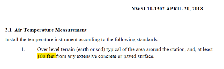
May of these stations don’t adhere to the 100 foot rule NOAA specification seen here.
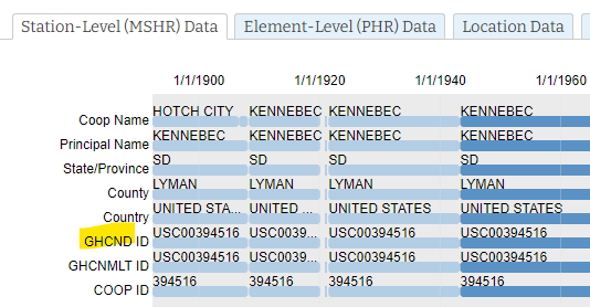
You can find that designtion in the HOMR database under the Station-Level tab, seen below.
These are used in homogenization processes and for infilling missing data. There are many more of these stations that the USHCN we originally looked at. Here is how to find them.
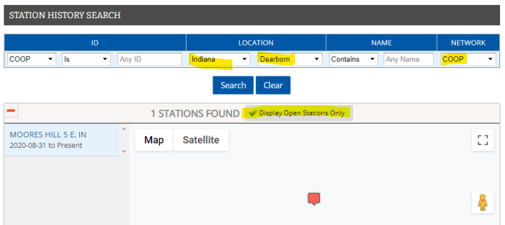
- Open up the HOMR web page and use the selector to choose where you live, such as state and county.
- Make sure you choose “COOP” in the right hand NETWORK selector, and then click on the “Display Open Stations Only” checkbox.
- The result will look something like this:
Click on the red balloon in the map, and you’ll then see another map below it with a blue square, click on it to get the lat/lon data:
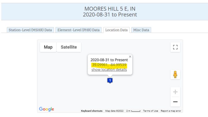
Paste the lat/lon data into google Earth (I use the downloadable program but the website version also works.)
Use the Google Earth Street view tools to locate the address, if it is a residence, use caution or select another station. Many stations are also on public facilities.
Can’t do any of this but want to help? Consider a donation to support the work.
THANK YOU – Anthony